The City of Norwalk is embarking on a visionary journey to revitalize its waterfront through the development of a new Strategic Harbor Plan. This ambitious initiative aims to harness the full potential of Norwalk Harbor, making it more accessible and beneficial for both residents and local businesses.
About the Strategic Harbor Plan
Norwalk is seeking expertise from qualified firms to conduct a comprehensive analysis of the Harbor's current uses. The goal is to craft a series of actionable recommendations that will enhance the Harbor's recreational and commercial appeal. This initiative seeks to open new avenues for public access to the Harbor and the city’s waterways, enriching the community's connection with its maritime heritage.
The project is funded through the American Rescue Plan Act (ARPA) Funds, emphasizing the importance of an active registration with the System for Award Management (SAM). Norwalk’s maritime history and its strategic location along the Long Island Sound have long been central to its identity and economy. With over 37% of its area covered by water, the city's unique geography offers numerous opportunities for development and engagement with the water.
The Strategic Harbor Plan encompasses the analysis of current recreational and commercial uses, identification of opportunities for increased Harbor use, and recommendations for the management and enhancement of public access and facilities. The plan will also address water quality, sustainability, resilience, and opportunities to expose the community, especially the youth, to maritime activities and careers.
Key Focus Areas
Management and Implementation: The plan will explore innovative strategies for the management of moorings, collection of fees, and the integration of technology in Harbor management.
Making Norwalk Harbor a Destination: Enhancements aim to attract regional boaters with improved facilities and services, making the Harbor a gateway to Norwalk’s vibrant entertainment and dining venues.
Public Access and Environmental Sustainability: Proposals will focus on expanding public access points, addressing water quality and climate change impacts, and promoting sustainable use of the Harbor.
Community Involvement: The strategy underscores the importance of community participation, from the plan’s inception to its adoption, to ensure it reflects the desires and needs of Norwalk’s residents.
The Strategic Harbor Plan will deliver a comprehensive audit of current Harbor uses, provide recommendations for development, and identify potential projects and funding opportunities. It will also emphasize public outreach, ensuring the community's voice is integral to the planning process. Ideally, this strategic plan should be completed within 12 to 18 months after execution of contract.
The Strategic Harbor Plan is a visionary step forward for Norwalk, promising to transform the Harbor into a more vibrant, accessible, and sustainable asset for the city. With the support of the community and the guidance of expert consultants, Norwalk is set to embark on a transformative journey that will benefit residents and businesses alike for generations to come.
Residents are encouraged to stay engaged with the planning process through the Norwalk Tomorrow platform and the City of Norwalk website, where updates and opportunities for participation will be shared. Together, we can shape a waterfront that reflects our community’s aspirations and respects our rich maritime heritage.
Affordable Housing Plan
City Planning Efforts
Norwalk is working on an Affordable Housing Action Plan to assess the City’s affordable housing needs and address their potential economic, environmental, and social equity impacts. The State of Connecticut defines "affordable rental and homeownership units” as housing that costs no more than 30% of a household’s income.
The Affordable Housing Action Plan will help the City to identify the different levels and types of affordable housing needed while providing guidance and direction on how to achieve that. The intent of the Plan is also to meet the State mandated 8-30j regulation and any updates to the regulation that are made during the planning process. There is currently a State Commission reviewing the requirements of the state-mandated affordable housing plan, so we expect there will be changes to this RFP.
Plan Goals
An inventory of the City’s existing housing and its current conditions
An analysis of housing needs, cost, and affordability
Trends in housing costs and housing development
A projection of housing needs for the medium - (next 5 years) and long-term (10 years).
A comparison between housing trends and housing needs
An analysis of the City’s housing programs and tools, including a gap analysis, their effectiveness in meeting goals, how well they are targeted towards housing needs, and how they can be improved
A desirable development scenario with input from the city, the public, and other stakeholders
Strategies to safeguard housing affordability and increase economic opportunity for current and future residents
Comprehensive implementation strategy and timeline, based on the affordable housing scenarios
Guidebook to affordable housing in Norwalk for residents and government officials
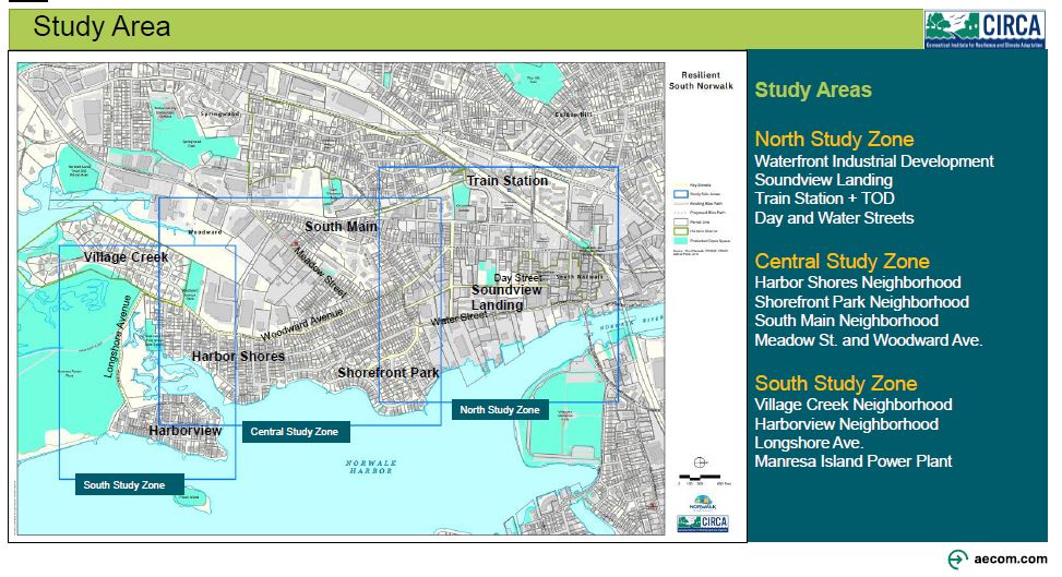
Climate change has made areas that are prone to flooding or extreme heat more vulnerable. The Connecticut Institute for Resilience and Climate Adaptation (CIRCA) initiated Resilient Connecticut in 2018 to plan for these weather-related challenges. CIRCA has identified Norwalk as a community that is not only subject to impacts from our changing climate but also has vulnerable populations and critical infrastructure that could be affected. Circa, in partnership with the Norwalk Planning & Zoning Department, will conduct an initial look at potential flooding resilience efforts and impact in South Norwalk. To lead this effort, CIRCA has brought on the consulting firm AECOM to help address these issues related to climate change and resilience.In South Norwalk, CIRCA research has shown that flood risks from storm surges, tidal flooding, heavy rain, and stormwater pose public safety issues for residents such as storm damage to buildings and infrastructure and access to lifelines, and evacuation routes during storms. In addition, much of the South Norwalk area is vulnerable to extreme heat because of the limited tree canopy, which the City is addressing, while also reducing the high amount of impervious surface. South Norwalk is home to a diverse population of residents with varying access to resources. Residents with fewer available resources - whether due to income, housing, age, transportation, or language access - are less able to adapt, and are therefore, more vulnerable to climate change.
Goal of Resilient South Norwalk
The Resilient South Norwalk Project’s goal is to develop strategies and adaptations that will help reduce the impact of climate-induced flooding and of extreme heat on the community’s residents, City infrastructure, and transportation, as well as improve the adjacent, valuable ecological systems. The kinds of solutions that may be considered are road elevations or relocations, flood protection systems, green infrastructure for stormwater management, increasing the tree canopy, and building retrofits for heat mitigation.As part of the project, Norwalk will review existing conditions and analysis by CIRCA on flooding and areas with extreme heat, as well as any current plans.
Planning Areas and Activities
The plan will focus on three zones in South Norwalk, identified on the map above as North, Central, and South. Within those zones the study will look at the following:
Creating flood mitigation options and needed adjustments to critical transportation corridors
Maintaining dry emergency evacuation corridors when it floods, as well as reducing flooding of critical community assets
Establishing “resilient corridors” to maintain access for residents, emergency vehicles, and critical services during storm events and flooding
Assessing how land is used, the density of buildings, particularly in areas with vulnerable populations
Reducing the impact of extreme temperatures and “heat islands” or pockets of the area that are significantly warmer than surrounding areas, including nature-based ways
Input and Participation
The planning team will work with the steering committee, and community stakeholders, such as neighborhood residents and businesses, to learn their priorities and then take them into consideration as they make plans. This will be done through four steering committee meetings, three public workshops, outreach materials, and updates via a website and social media. The goal is to wrap up the project in May of 2023.This CIRCA-funded project is a component of the U.S. Department of Housing and Urban Development (HUD) National Disaster Resilience Competition award to the State of Connecticut, administered by the Connecticut Department of Housing. Resilient Connecticut provides the state with funds for the design and engagement process.
Norwalk Industrial Waterfront Land Use Plan
Norwalk Industrial Waterfront Land Use Plan
As an extension of the Norwalk Industrial Zones Study, the City of Norwalk has developed an urban waterfront land use plan. The study focused on existing and future land use along the waterfront, taking public access and recreation into consideration. The plan also looked at information about the water itself and environmental issues, including navigation channels, water quality, and flood hazards.
The final plan will be used to inform future rezoning efforts, among other things, including:
Prioritizing land use policy which encourages water dependent uses
Economic development recommendations
Identifying capital projects, paired with suggested timelines and funding sources
Why Is There a Plan for Norwalk’s Urban Waterfront?
Urban waterfronts serve many purposes – they are centers for economic activity that are dependent on the water and are desirable spaces for public recreation. They are also sought after locations for housing and commercial uses like restaurants and retail. Waterfronts must also respond to many pressures and changes such as rapidly evolving economic conditions and increased flood risk.
In Norwalk, our Harbor Plan prioritizes water dependent uses. The current waterfront includes a number of long standing industrial and marine commercial properties that add to Norwalk’s maritime character.
This plan will help Norwalk to take stock of the needs, aspirations, and ideas for the future of the city’s waterfront. It providesa framework for regulations, rezoning recommendations, and projects needed to pursue a healthy, vibrant, and dynamic waterfront for Norwalk that balances public access, water-dependent land uses, water quality, and flood resiliency.
Area the Plan Covers
The above map shows the boundary of the Waterfront Plan area and includes:
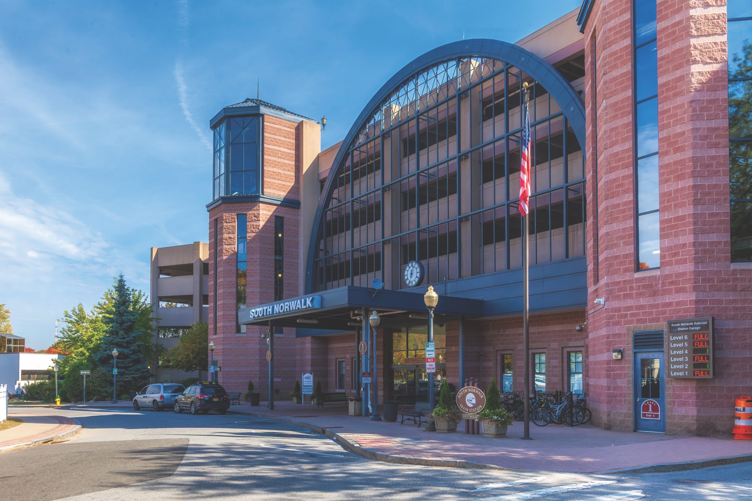
The Norwalk Redevelopment Agency is implementing its Norwalk TOD Redevelopment plan. Part of this plan includes a study of the area surrounding the South Norwalk train station. Under the guidance of Norwalk Redevelopment Agency and the City of Norwalk, a study of approximately 26 acres surrounding the South Norwalk Train Station has been adopted.
The study was conducted in two phases. Phase One established baseline conditions for the South Norwalk train station area by looking at the following:
The highest, best use of the area
Accommodating affordable housing (at a 1:1 ratio)
Parking and infrastructure needs and limitations
Opportunities for public/private partnerships that can support the recommendations of the study
Improvements to the Lexington Avenue Historic District through façade upgrades and development
Improving connections between the neighborhood and the train station
Incorporating findings from this South Norwalk train station plan into the larger South Norwalk Transit-oriented development plan
Phase Two of the South Norwalk Train Station Area Study established more concrete details based on the findings of Phase I including:
The appropriate density, massing, building, and streetscape design within the existing redevelopment plan and existing zoning for SoNo Station Design District
The impact of COVID-19 on current market demand and construction cost viability
The potential for establishing a multimodal transportation hub at the South Norwalk train station, including the feasibility of:
Relocating the bus station hub near the train station
Improving accommodations for pedestrians, bicycles, scooters, pick-up and drop-off vehicles
Adding on-demand transportation, micro-transit, and fixed route uses
The economic benefits and impacts of the recommended development options
Citywide Plan of Conservation and Development (POCD) 2019 - 2029
Our Vision for Norwalk
By 2029, the City of Norwalk has become a national example of a small city that boasts a thriving and dynamic economy; varied housing choices for all income levels; many safe and convenient ways to get around the city, including walking and biking; connected, accessible and beautiful open spaces; a commitment to lifelong learning; and an active and resilient coastline. Norwalk is the center of art, culture and entertainment for our region. We combine the character of a historic New England community on the coast of Long Island Sound with a thriving city in the country’s largest metropolitan area.
Our prosperity is rooted in retaining the foundation of our diversified economy, including health care and Fortune 500 companies, while attracting businesses in emerging fields. These businesses allow many Norwalk residents to work where they live, provide living-wage jobs for all skill levels, and create a strong non-residential tax base
We’re a center of culture and entertainment, attracting local and regional visitors to our urban districts of SoNo and Norwalk Center; our museums, aquarium and historic sites; and our parks and natural open spaces.
We’re proud of our racial and ethnic diversity and continue to welcome people from around the world.
Norwalk’s excellent quality of life offers a choice of housing options in neighborhoods ranging from lively urban centers of varied densities and suburban–style areas, to quiet, treefilled enclaves and coastal villages.
We’re a city of transportation choice: a connected, walking and biking city, well-served by public transportation, safe and convenient pedestrian and bicycle routes to city destinations, well-maintained and well-functioning local streets, and efficient regional transportation links.
Norwalk’s parks, natural open spaces, and waterfront attractions work as a green and blue network linked by trails and other routes and offering recreational and nature experiences to all.
Norwalk protects and enhances the natural environment and land, water, and air resources for the benefit of future generations.
Norwalk Harbor remains a major center of water-based activities on Long Island Sound, providing opportunities for recreation and commerce: public access for recreation and education, recreational boating, commercial shellfishing, and other vital economic, environmental, and cultural values and opportunities.
Norwalk embraces lifelong learning through public-private partnerships. Our schools and Norwalk Community College promote educational achievement to create a highlyqualified workforce for 21st-century jobs. Norwalk seeks a strong higher education presence in its urban center to spark art, innovation and activity.
We’re committed to energy- and resource-efficiency, as well as to pursuing solutions and adaptations to the expected impacts of climate change and sea-level rise–coastal and inland flooding, extreme storms, extreme temperatures, and drought.
The City’s infrastructure, public facilities, and public services are resource-efficient, well-maintained, cost-effective, sustainable, and resilient.
Manresa Island
Manresa Association Findings & Recommendations
Manresa Island consists of two parcels that occupy approximately 144 acres of Norwalk’s shoreline. Since 1960, a power plant has been located on the southern parcel; first operating as a coal fired plant that was converted to oil in 1972. In 2012, the site was inundated with storm surge during Hurricane Sandy and was subsequently closed in 2013. The closure of a power plant triggers a long process of reuse planning that involves multiple phases including decommissioning, remediation, and potential redevelopment.
The Manresa Association was formed in 2013 as an advocacy group dedicated to ensuring that Manresa Island is environmentally safe, provides open space and conservation habitat, and contributes to the physical beauty of Norwalk and the Long Island Sound coastline. The association comprises over 900 households and several local neighborhoods and clubs.
In 2017 the Manresa Association and the City of Norwalk partnered to conduct a study with the aims of identifying potential future uses of the property and assessing the potential economic impact of those uses. The study team worked closely with the project steering committee, which was composed of representatives from the City of Norwalk (Redevelopment Agency, Planning Department, Economic Development, and various Commission Members) and the Manresa Association. NRG Energy, owners of the plant, has provided access to the property and representatives from NRG attended a public workshop in support of the study.
This report provides an overview of environmental and ecological conditions of the property, remediation efforts to date and planned and potential remediation approaches, regional market conditions that will influence potential reuse of the property, and recommended reuses of the site based upon those conditions.
See Findings and Recommendations ReportRead the Latest on the Manresa Island Transformation: Norwalk's Exciting New Waterfront Destination
The City of Norwalk is developing a holistic, long-term traffic management and transportation improvement plan for managing the various modes of transportation within the City. The plan will provide a roadmap for innovative transportation solutions that are safe, economical, accessible, sustainable, livable, and suitable for Norwalk that enhances connectivity and mobility. This plan will guide the transportation policy and investments in the City transportation network over the next 10 to 20 years.
The Transportation Master Plan’s overall goal is to improve the various forms of urban mobility with future technologies and transportation modes in mind. Other goals include: citizens who need help getting to the doctor, to the visitor looking to shop, dine or visit an entertainment venue in town.
Minimizing traffic congestion
Improving the quality of life
Managing curb-space
Promoting favorable public health and social equality
The plan will include the following:
Upgrading existing roadways to provide increased capacity, efficiency and safety
Increasing micro-mobility options including electric vehicle on demand shuttles, ride sharing, walking and biking
Including Vision Zero initiatives that prioritize equitable transportation options and traffic safety through design, engineering, policies, enforcement, community engagement, and education
Addressing on-street residential parking
Assessing issues such as traffic calming and truck traffic
Having a well-planned and coordinated transportation network is vital to the economic health of Norwalk. A well-developed and achievable transportation plan will contribute to ensuring the City’s viability and vitality for years to come.
Recent Activity
With input from our Technical Advisory Committee, key stakeholders, and the Norwalk community, we have created a Needs Assessment to highlight mobility issues and opportunities. This document sets the stage for the development of strategies to improve Norwalk’s transportation infrastructure and mobility opportunities.
An ambitious set of goals and draft performance measures has been drafted to guide policy and project development to come from the Transportation Master Plan.
Our online survey has generated more than 1,100 responses and we have more than 750 pins dropped in our virtual mapping activity to call out local concerns.
A list of strategies was developed as a toolbox approach to addressing plan needs in the context of the six plan goals.
A series of early action concept plans have been developed as part of the plan. These concepts illustrate the types of improvements that may address current funding opportunities, near-term solutions to known issues, and strategic or long-term projects to address plan goals.
The Norwalk, CT Five-Year Consolidated Plan (Con Plan) is mandated by federal law and regulations promulgated by the U.S. Department of Housing and Urban Development (HUD) for the City to receive federal funding for affordable housing and community development initiatives benefitting primarily lowand moderate-income persons. This Con Plan consolidates into a single document the planning and application requirements for the Community Development Block Grant (CDBG) program.
Con Plans must be prepared and submitted to HUD every three to five years. Norwalk uses a five-year Con Plan cycle; this plan covers fiscal years 2020-2024. The purpose of the Norwalk, CT Con Plan is to:
Assess the City’s affordable housing and community development needs;
Analyze the City’s housing markets;
Articulate the City’s priorities, goals, and strategies to address identified needs; and
Describe the actions the City will take to implement strategies for affordable housing and community development.
Norwalk's Con Plan for FY 2020 – FY 2024 provides data on trends and conditions related to the City’s current and future affordable housing and community development needs. The analysis of this data has been used to establish priorities, strategies, and actions that the City will undertake to address these needs over the next five years. Annually, the City will develop its
Annual Action Plan in which it will describe the planned investment of federal resources to implement specific activities.
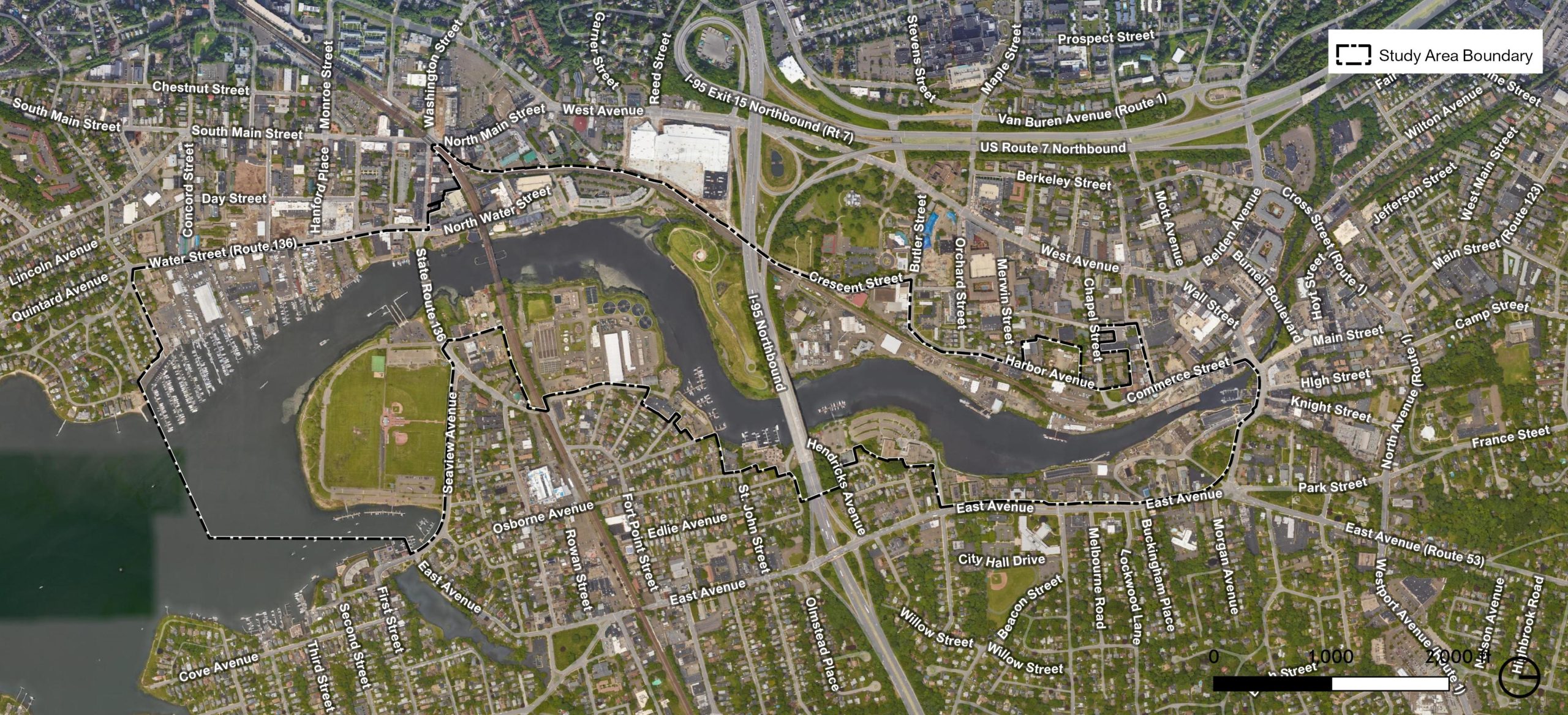
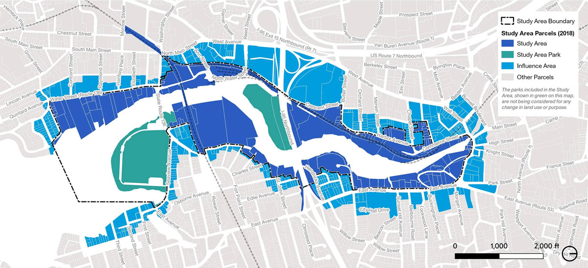 The above map shows the boundary of the Waterfront Plan area and includes:
 The study was conducted in two phases. Phase One established baseline conditions for the South Norwalk train station area by looking at the following:
