 We’ve written about what makes cities livable and what people are looking for in a city. There are various urban planning approaches that put and keep people at the forefront. Designing a city so it is people oriented brings in two subjects we’ve covered, transit-oriented development (TOD) and designing public spaces to make them more bikeable, walkable and encourage community (also known as placemaking). Below we take a closer look at some of the factors that make up people-oriented urban design.
Planning Cities With People-oriented Design
We’ve written about what makes cities livable and what people are looking for in a city. There are various urban planning approaches that put and keep people at the forefront. Designing a city so it is people oriented brings in two subjects we’ve covered, transit-oriented development (TOD) and designing public spaces to make them more bikeable, walkable and encourage community (also known as placemaking). Below we take a closer look at some of the factors that make up people-oriented urban design.
East Norwalk Neighborhood Tod Plan
View Draft Plan
East Norwalk TOD Study Draft Recommendations
Transit-Oriented Development Plan Moving Forward in East Norwalk
 Norwalk has been undergoing planning for East Norwalk to guide growth and development in and around the East Norwalk train station. The plan is being developed with the help of stakeholders including the public, area businesses, and other city residents and representatives to create a vision for the future, and help guide recommendations for appropriate uses for the land and scale of development in the East Avenue train station area. Below we’ll take a look at some of the proposed recommendations
A New Village District for East Norwalk
One significant recommendation is the creation of a new village district for the area, concentrated on East Avenue. This will require all development to adhere to design guidelines that control building architecture, streetscape, site layout, signage and landscaping . The city would also allow some buildings to have additional height and a moderate increase in the number of residential units, above ground floor commercial spaces, provided they include certain amenities that positively impact the community. Benefits of this include additional revenue for property owners as well as promoting mixed-use development, so residents could live close to commercial and transportation options. As part of developing the district, the plan proposes putting in place a street and facade improvement program in the areas of Charles Street & Osborne Avenue, north of Fort Point Street, similar to the program used in SoNo.What Could New Development Look Like?
So what could the new village district look like? The study team put together a rendering and buildout of the corner of East Avenue and Winfield Street to illustrate what is possible. The new regulations could allow slightly taller buildings (1 additional story than currently allowed) in exchange for a large pedestrian plaza with other features such as fountains, public arts, public WIFI and/or public seating, as well as a shared parking lot to the rear of the development. In addition, sidewalks around this parcel could be widened to encourage pedestrians and to make room for possible outdoor dining space. It is important to note that this plan has no mechanism or recommendation to take anyone’s property or force them to change their current use. The Plan is meant to guide development, if and when change occurs.Improvements Toward the Norwalk River
In East Norwalk, as you go closer to the Norwalk River, one possible improvement would be to explore the relocation of the DPW garage elsewhere in the City. This site could be used for a variety of other uses, ranging from marine commercial use to open space. Closer to South Norwalk, the study team suggested the creation of a promenade along Seaview Avenue, connecting the Cove Avenue area to SoNo. The promenade would be another great resource for Norwalkers, with amenities that could be used for recreational and entertainment purposes.Next Steps
These recommendations will be posted in full in a draft plan and area residents, business owners and others with an interest in the area will have the opportunity to give their feedback to the City. Once put in place, the revitalization of the area around the East Avenue train station will be yet another step toward ensuring that Norwalk is a great place to live, work and play.Read Final Plan
Plan AppendicesEast Norwalk Transit Oriented Development Plan Draft Zoning & Land Use Recommendations
Stakeholders Weigh In On Transit-Oriented Development for East Norwalk
 The public was given the opportunity to hear progress and give feedback on the East Norwalk Transit-Oriented Development Plan at a public forum in November 2019. The 50 + participants were updated on the progress to-date following two community workshops, one on what people envisioned for the area held in March 2019, and the other on the different kind of transit-oriented development options available, held in July 2019. The public also heard about the key drivers of the Plan and the broad recommendations that address these key drivers. The final in-depth recommendations being developed in collaboration with the Oversight Committee are based on these broad recommendations. Additionally, attendees were taken through a market analysis of the project from an outside consultant that looked at the feasibility of development in East Norwalk and Norwalk as a whole.
Public Priorities
During the public open house, participants were asked to vote on their priorities for various recommendations for development in East Norwalk. This was done via interactive boards on which attendees were asked to put stickers on the recommendations they preferred. Below are the results.Highest Priority Recommendations:
- Enhance leisure opportunities with wider sidewalks, mid-block crossings, pocket parks, plazas, community gardens, and publicly accessible open spaces.
- Improve mobility for everyone with traffic calming tools and methods to slow traffic and discourage cut-through traffic.
- Preserve and enhance existing residential neighborhoods.
Lowest Priority Recommendations:
- Examine two-way traffic circulation options around the cemetery.
- Add road signage to increase driver awareness.
- Increase turnover of prime on-street parking.
Next Steps
The draft report, including recommended zoning and design changes, is expected to be completed in early 2020, and with Committee feedback, will be available for public comment. Ultimately, the Planning Commission will amend the recently adopted Citywide Plan (POCD) to incorporate the recommendations within the East Norwalk TOD plan. As part of that process the Planning Commission will hold two public hearings and will also refer the plan to the Common Council.Click Here To View The Presentation
November 2019 Open House Presentation
East Norwalk Transit Oriented Development (TOD) Public Meeting Presentation
East Norwalkers Lend Their Vision to Transit-Oriented Development Plan
 More than 70 people attended a workshop on July 25 at Norwalk City Hall to gather the public’s ideas and visions for the East Norwalk Transit-Oriented Development (TOD) Plan. The TOD Plan will be a future guide for appropriate uses for the land and the scale of market-supportable and development in the East Avenue area surrounding the train station.
Who Participated
The majority (70%) of the 73 people who attended and filled out a questionnaire were residents of East Norwalk while 48% were East Norwalk business or property owners. Also among the participants, 26% commuted from East Norwalk and 35% worked in or were patrons of East Norwalk retail and restaurants. Just over 30% were a resident or business or property owner in Norwalk (or the surrounding region). The largest age representation at the workshop were those 56-65 (33%); and the second largest group represented were those 46-55, at 26%. Just 9% of attendees were between the ages of 18 and 35, while 15% were 66-80. Four percent of participants were over 80 years old.Survey Preferences
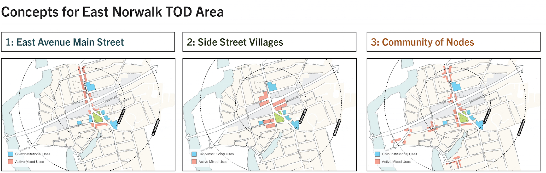
Workshop attendees participated in several different exercises to get their thoughts and opinions about the East Norwalk TOD area. The first exercise invited attendees to evaluate images within four categories: Housing; Commercial and Mixed Uses; Connectivity and Access; and Public Space. Participants were asked to rank their enthusiasm toward each image, from highly desirable to neutral, down to highly undesirable, based on its suitability with regards to East Norwalk. To gauge the development goals and vision of the community for the East Norwalk TOD area, attendees were shown different types of development that could be encouraged via incentives and controls. The alternatives included developing the area around East Avenue/Main Street based on Side Street Villages or smaller Community Nodes or Centers.