Public Information Meeting Announcement West Rocks Road Sidewalks
SAVE THE DATE
West Rocks Sidewalks are Coming!
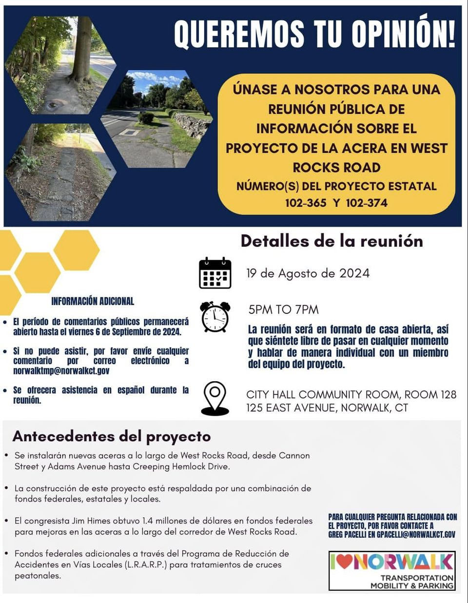
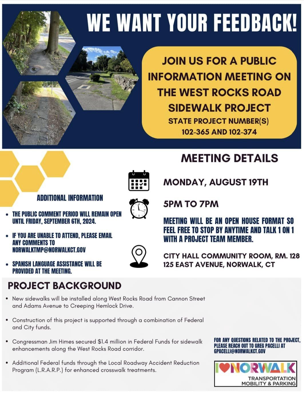
We want your feedback! Join the City at the Transportation, Mobility, and Parking (TMP) Team’s Public Information Meeting regarding the West Rocks Road Sidewalk Project on Monday, August 19th, from 5-7 pm at the City Hall Community Room, Room 128. It will be in an open house format, so you may arrive anytime and talk to a member of the project team 1-on-1.
Preliminary Design for the project has been completed and is slated for construction under Federal and City funds. In 2022, TMP proposed this project to Congressman Jim Himes and he secured $1.4 million in Federal Funding. In addition, the Connecticut Department of Transportation will be administering funding through the Local Road Accident Reduction Program (L.R.A.R.P.) for sidewalk and crosswalk enhancements along the West Rocks Road corridor.
The TMP Team is eager to present the Preliminary Plans to the community and receive feedback. Based on your feedback, we should have the design fully completed by late Fall 2024.
For any questions, please contact Greg Pacelli, Transportation Planner, at gpacelli@norwalkct.gov.
VIEW WEST ROCKS MEETING FLYER
Route 1 Corridor Study Public Meeting
Route 1 Corridor Study Public Meeting
When: Monday, May 20th | 5:30 pm - 7:30 pm
Where: Jefferson Elementary School
Transportation, Mobility, and Parking (TMP) will be holding a public information meeting on Monday, May 20th from 5:30 to 7:30 PM at Jefferson Elementary School (75 Van Buren Avenue) to engage the community, collect feedback, and share the vision and goals of the Study. The Route 1 Corridor means a lot of different things to a lot of different people; we were hoping by way of this email you could share this with the local business community. We would like to have as many stakeholders in the corridor/Norwalk businesses present at the meeting.
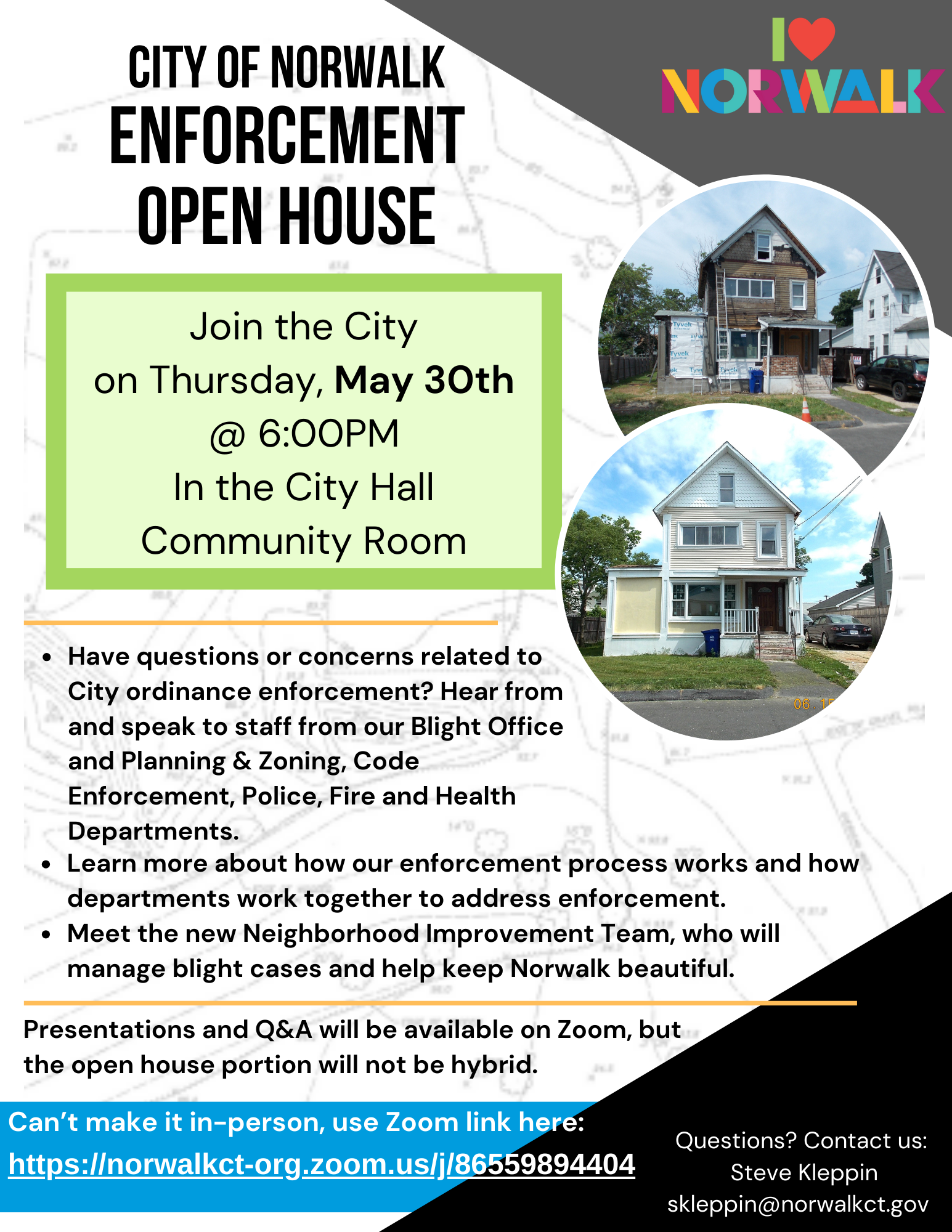
Interested parties/businesses can find more information about the project here: Norwalk Route 1 Corridor Master Plan Study – Western Connecticut Council of Governments (westcog.org). The project webpage (hosted by WestCOG) allows those interested to sign up for project updates, contact the team for more information, and also register for the public meeting (although not a requirement to attend).Enforcement Open House
The Norwalk Complete Streets Project
After a successful completion of the Transportation Master Plan, the City of Norwalk is putting efforts into motion to improve the accessibility, safety, and convenience of the streets in Norwalk, CT. To that end, the department of Transportation, Mobility, and Parking is commencing The Norwalk Complete Streets Project. In this article, we'll give you an overview of this project, a comprehensive timeline, and opportunities for involvement.
What Are Complete Streets?
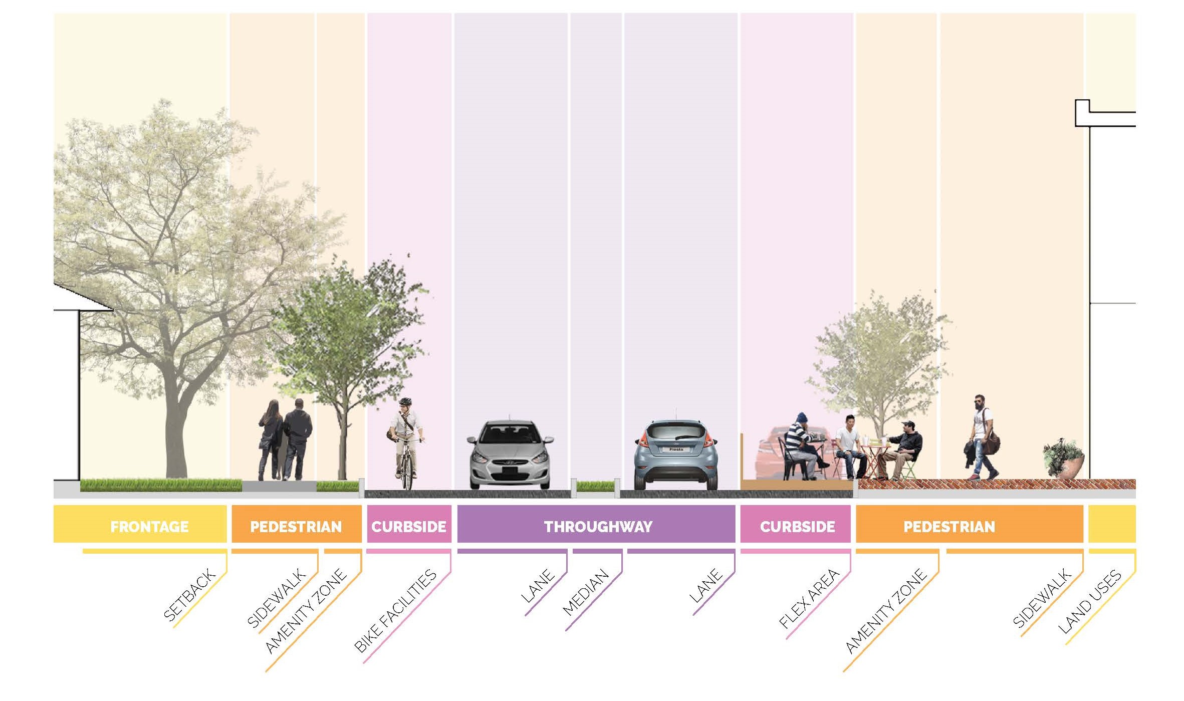 “Complete streets” are des
igned and operated with the safety, mobility, and accessibility needs of users of all ages and abilities in mind. They are streets that are safe and convenient for pedestrians, bicyclists, transit riders, and drivers of all ages and abilities.
The Norwalk Complete Streets Policy and Design Manual will help build a network of complete streets through the development of two critical documents:
- A Complete Street Policy, Ordinance, and Integration Plan: This document will institutionalize and streamline the integration of complete streets elements into future municipal transportation planning and land use decisions. The ordinance will establish procedures for evaluating street projects to ensure that they meet the needs of all users. The integration plan will provide recommendations for the procedures of additional City departments which will be affected by the adoption of complete streets.
- A Complete Streets Design Guide: This will guide the design, construction, and implementation of the complete streets ordinance. The design guide will include recommended lane widths, pedestrian and bicycle infrastructure, stormwater management techniques, and other strategies for different types of roads.
Why Complete Streets
Complete streets planning is about more than mobility choices. It’s about the examination of how transportation infrastructure impacts the ability of residents and visitors to access employment and key services, enjoy recreation and cultural amenities, and live healthy lives, among many other factors. The implementation of complete streets policies and guidelines is deeply tied to municipal priorities: should the city prioritize equity, safety, livability, and connectivity in transportation decision-making?
This plan will build upon the numerous planning efforts the city has already undertaken to promote safety and accessibility for all roadway users, and will incorporate the aspirational goals of the recently completed Transportation Master Plan. This initiative will maintain the high level of community engagement for a complete streets policy in the city. The plan will promote economic sustainability and resiliency through sound design and policy recommendations for balanced development. Finally, it will provide the City of Norwalk with a toolbox and strategies to implement complete streets improvements in a responsive and efficient manner.
Project Timeline
- Existing Policy Review, Best Practices Research, and Stakeholder Interviews (Winter - Spring 2023)
- Network Analysis (Current)
- Policy Development (Current)
- Walkability Workshop, Public Workshop, and Demonstration Project (Current, continues through Fall 2023)
- Design Manual Development (Fall - Winter 2023)
Stay Informed and Get Involved
It is our goal for residents, business owners, and stakeholders to be able to give input and collaborate on the creation of the Complete Streets Policy and Design Guide. Opportunities for collaboration and engagement will include:
Steering Advisory Committee: A group of local leaders and public officials that will be among the first to review study documents and provide feedback before they are finalized.
Online App/ Survey: A survey to help the project team identify participants’ familiarity with complete streets elements and agree with the manual’s goals and vision.
Workshop: The project team will hold a workshop to educate residents about complete streets, gather input on what it’s like walking, biking, taking transit, driving, and parking in Norwalk, and provide input into the plan for the demonstration project. The workshop will allow participants to have direct input into the design of streets.
Demonstration Project: The City will be sponsoring a demonstration project, which will allow the public to see one of the plan’s recommendations in place as part of a temporary installation. The public is invited to give feedback about what is and is not working before more substantial investments are made.
Check this webpage regularly for updates on opportunities for community engagement.
If you have any questions, comments, or concerns please contact the project team using:
CompleteStreets@norwalkct.gov
Or visit the
Norwalk, CT Transportation, Mobility, and Parking website. Calf Pasture Beach Parking Lot and Green Infrastructure Project: A Step Towards Sustainable Development
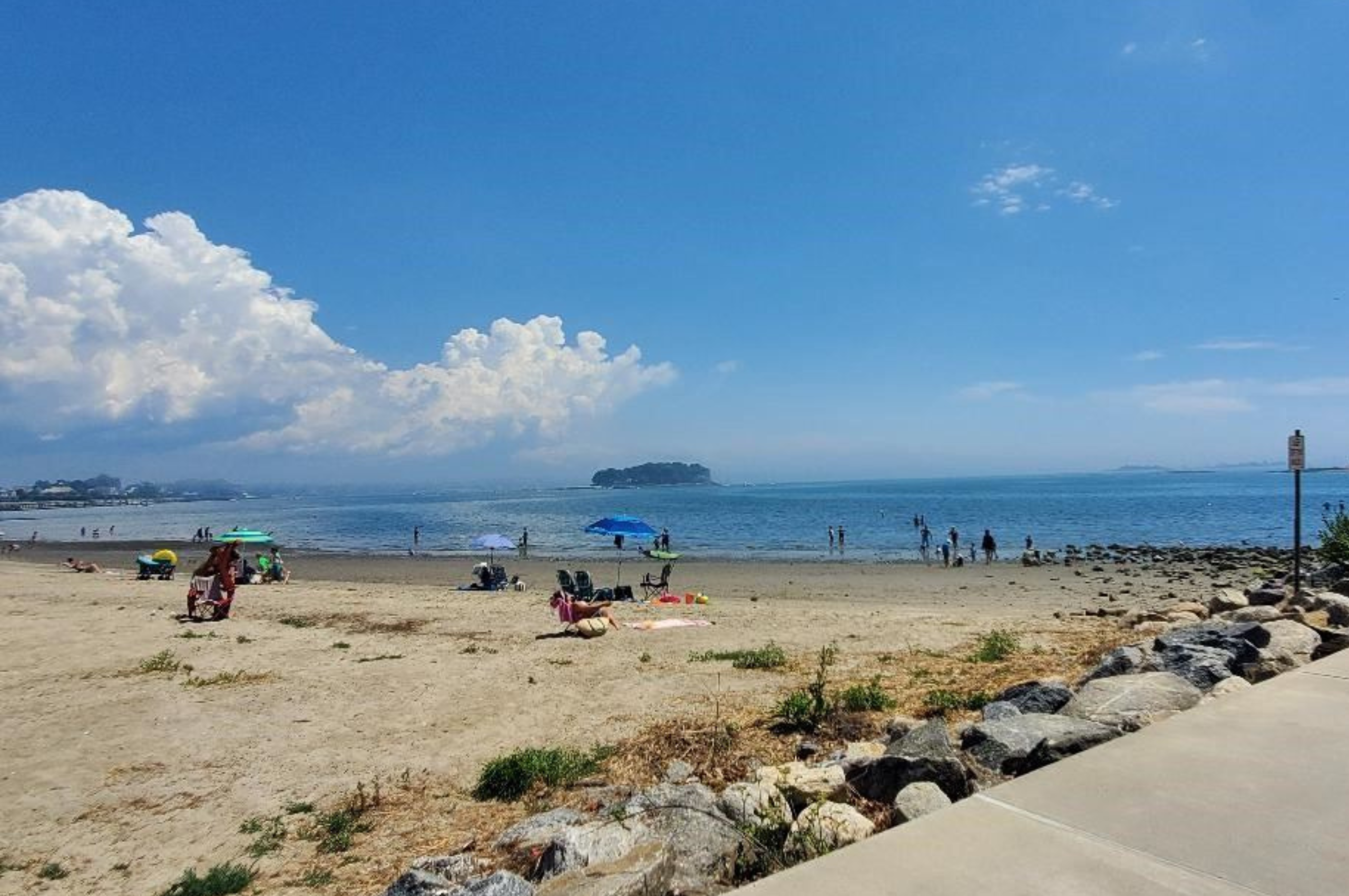 In Norwalk, CT, the Calf Pasture Beach Parking Lot and Green Infrastructure project is an excellent example of how sustainable development can be achieved through the integration of green infrastructure. Sustainable development is a concept that emphasizes the importance of meeting the needs of the present without compromising the ability of future generations to meet their own needs. With the integration of green infrastructure into urban development, we can mitigate these impacts while still creating livable and functional spaces.
In this blog post, we will discuss the Calf Pasture Beach Parking Lot and Green Infrastructure project, its benefits, and its potential to inspire similar projects in other areas.
In Norwalk, CT, the Calf Pasture Beach Parking Lot and Green Infrastructure project is an excellent example of how sustainable development can be achieved through the integration of green infrastructure. Sustainable development is a concept that emphasizes the importance of meeting the needs of the present without compromising the ability of future generations to meet their own needs. With the integration of green infrastructure into urban development, we can mitigate these impacts while still creating livable and functional spaces.
In this blog post, we will discuss the Calf Pasture Beach Parking Lot and Green Infrastructure project, its benefits, and its potential to inspire similar projects in other areas.
About the Project
The Calf Pasture Beach Parking Lot and Green Infrastructure project is a collaborative effort between the Norwalk Department of Public Works and the Norwalk Recreation and Parks. The project aims to transform the existing parking lot at Calf Pasture Beach into a sustainable and functional green infrastructure system that will reduce the amount of polluted stormwater runoff entering Long Island Sound.
The project involves the installation of a permeable pavement system(3125 sf), and eight bioretention areas and the planting of native vegetation(~21 trees, 59 shrubs, and hundreds of perennials/grasses). The permeable pavement system will allow stormwater to infiltrate into the ground, reducing the amount of runoff that enters the nearby waterways. The bioretention areas will provide additional treatment of stormwater through a natural process of filtration and absorption. The native vegetation will help absorb stormwater, provide a habitat for wildlife, and beautify the area.
[gallery columns="4" ids="2189,2190,2191,2188"]
Benefits of the Calf Pasture Beach Project
The Calf Pasture Beach Parking Lot and Green Infrastructure project has numerous benefits. Firstly, it will improve water quality in the Long Island Sound by reducing the amount of polluted stormwater runoff entering the waterways. This, in turn, will help to protect aquatic life and create a healthier environment for recreational activities.
Secondly, the project will increase the amount of green space in the area, providing a more aesthetically pleasing and functional space for visitors. The addition of native vegetation will also provide a habitat for wildlife, contributing to the overall health of the ecosystem.
Lastly, the project demonstrates how sustainable development can be achieved through the integration of green infrastructure. By transforming an existing parking lot into a sustainable and functional green infrastructure system, the project is an example of how we can mitigate the negative impacts of urban development while still meeting the needs of the community.
Potential for Similar Project
The Calf Pasture Beach Parking Lot and Green Infrastructure project has the potential to inspire similar projects in other areas. As urban areas continue to expand, it is becoming increasingly important to integrate green infrastructure into urban development. The benefits of green infrastructure are numerous, including reducing stormwater runoff, improving water quality, creating habitat for wildlife, and improving the overall aesthetics of the area.
By showcasing the benefits of green infrastructure, the Calf Pasture Beach Parking Lot and Green Infrastructure project can inspire other communities to follow suit. The project is a reminder that sustainable development is possible and that it is up to us to take action to ensure a healthy and prosperous future for ourselves and future generations.
Conclusion
The Calf Pasture Beach Parking Lot and Green Infrastructure project is an excellent example of how sustainable development can be achieved through the integration of green infrastructure. The project demonstrates how we can mitigate the negative impacts of urban development while still meeting the needs of the community. The project has numerous benefits, including improving water quality, providing habitat for wildlife, and improving the overall aesthetics of the area.
In addition to the above benefits, the Calf Pasture Beach Parking Lot and Green Infrastructure project will also include the addition of a safe and protected pedestrian boulevard and a redesign of the entrance and exits to improve access and exit flow. The new pedestrian boulevard will provide visitors with a safe and enjoyable space to walk, run, or bike, away from vehicle traffic. This will recreate a beach walk from sand to surf over thermoplastic imagery designed for Norwalk. The redesign of the entrance and exits will improve traffic flow, reduce congestion, and enhance safety for all users.
The integration of these additional features highlights the importance of considering all aspects of sustainable development, including the safety and accessibility of the space. By creating a more accessible and safer environment, the project will encourage more people to visit and utilize the area, contributing to a more vibrant and active community.
The success of the project has the potential to inspire similar projects in other areas, contributing to a more sustainable city and livable future for all.
Norwalk Transportation Master Plan Open House
Norwalk Transportation Master Plan Open House
December 6, 2022
6:00-8:00pm
Community Room
Norwalk City Hall
125 East Avenue, Norwalk
Public Meeting on the South Norwalk Train Station Transit-Oriented Development Study
Public Meeting on the South Norwalk Train Station Transit-Oriented Development Study
6:30pm
Via Zoom
30-Minute Cities: A New Urban Planning Trend?
 The concept of “30-minute cities” was originally conceived for the city of Sydney, Australia as a way to make the city easily accessible to all. It is a concept that can be adopted in other parts of the world as a way to develop a city strategically so that people can reach important destinations around the city within a reasonable time using a variety of methods of transportation, including car, bus, train, even biking or on foot.
Access as a Driving Force in Urban Development
When planning for urban development around 30-minute cities, access is the focal point, or improving connectivity within a city. The goal is to reduce the amount of time people need to travel to get to critical points around the city such as work, school, shopping, health and recreational activities. Access also includes opportunities for all people, regardless of socioeconomic status, gender, ethnicity or physical or mental ability. One way to do this is to increase the number of available travel options close to where people live.
Ways to Create 30-Minute Cities
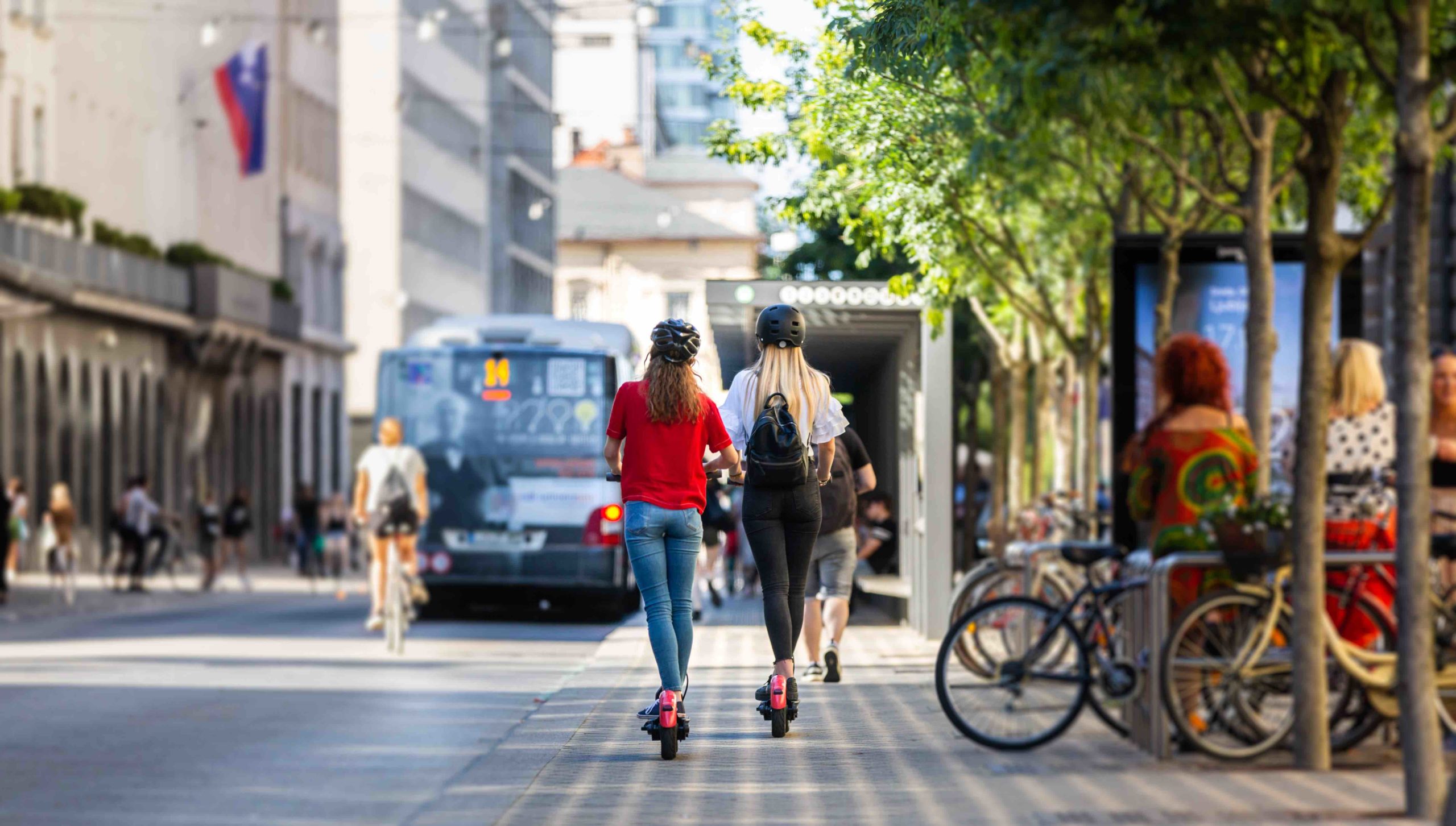
Creating 30-minute cities takes a number of steps. Some include giving people a variety of ways to get around the city, including public transportation, private cars, taxi, ride-shares as well as walking, bicycling, and scootering. Others include creating important destinations in close-proximity to each other and to transportation hubs. There are a few approaches that cities can take.
Urban Transportation
Cities can take both short-term and long-term steps to increase access to different types of transportation, as well as to improve the speed at which people can get from one place to another. Short-term actions can include retiming traffic signals, bike sharing programs, protected bike lanes, as well publishing public transportation timetables. Longer-term steps could include implementing rapid bus networks, and planning development around transit hubs.
Urban Density Planning
Cities can promote and prioritize redevelopment that creates well-designed urban neighborhoods or centers where people can live, work and play within a 30-minute radius by foot, bike, car or public transportation. This is commonly known as transit-oriented development. This development should also offer a variety of housing options, including affordable housing, and different employment options to include access to a range of people.
Private/Public Partnerships
To be successful, transit-oriented development needs both public and private input, support, and funding. Developing neighborhoods that include residences and businesses will need the participation and investment of private developers. Government participation is also key for infrastructure improvements to ensure a variety of transportation options and incentives to the private sector.
The concept of 30-minute cities is certainly do-able for many urban areas. Better mobility, including integrated and varied transportation options, neighborhood planning, and public and private partnerships will all help to make our cities a better place to live, work and play.Transportation Master Plan
Recent Activity Next Steps Documents Draft Master Plan
About the Plan
The City of Norwalk is developing a holistic, long-term traffic management and transportation improvement plan for managing the various modes of transportation within the City. The plan will provide a roadmap for innovative transportation solutions that are safe, economical, accessible, sustainable, livable, and suitable for Norwalk that enhances connectivity and mobility. This plan will guide the transportation policy and investments in the City transportation network over the next 10 to 20 years.
The Transportation Master Plan’s overall goal is to improve the various forms of urban mobility with future technologies and transportation modes in mind. Other goals include: citizens who need help getting to the doctor, to the visitor looking to shop, dine or visit an entertainment venue in town.
- Minimizing traffic congestion
- Improving the quality of life
- Managing curb-space
- Promoting favorable public health and social equality
The plan will include the following:
- Upgrading existing roadways to provide increased capacity, efficiency and safety
- Increasing micro-mobility options including electric vehicle on demand shuttles, ride sharing, walking and biking
- Including Vision Zero initiatives that prioritize equitable transportation options and traffic safety through design, engineering, policies, enforcement, community engagement, and education
- Addressing on-street residential parking
- Assessing issues such as traffic calming and truck traffic
Having a well-planned and coordinated transportation network is vital to the economic health of Norwalk. A well-developed and achievable transportation plan will contribute to ensuring the City’s viability and vitality for years to come.
Recent Activity
- With input from our Technical Advisory Committee, key stakeholders, and the Norwalk community, we have created a Needs Assessment to highlight mobility issues and opportunities. This document sets the stage for the development of strategies to improve Norwalk’s transportation infrastructure and mobility opportunities.
- An ambitious set of goals and draft performance measures has been drafted to guide policy and project development to come from the Transportation Master Plan.
- Our online survey has generated more than 1,100 responses and we have more than 750 pins dropped in our virtual mapping activity to call out local concerns.
- A list of strategies was developed as a toolbox approach to addressing plan needs in the context of the six plan goals.
- A series of early action concept plans have been developed as part of the plan. These concepts illustrate the types of improvements that may address current funding opportunities, near-term solutions to known issues, and strategic or long-term projects to address plan goals.
- The complete Draft Transportation Master Plan is published online for public review and comment.
Next Steps
- Review and incorporate public feedback on the Draft Transportation Master Plan.
Documents
Public Informational Meeting (12/6/22)
I received a parking ticket, what do I do?
Please click here to
pay
Please click here to
appeal