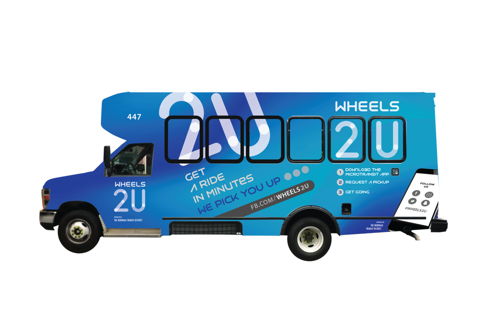
 In the Fall of 2018, Norwalk plans to unveil Wheels2U, a new form of public transportation allowing residents to request rides and be picked up in minibus vehicles, creating an on-demand ridesharing service. While the minibus will be carrying other riders, they will all be dropped off at their final destinations. Here are some facts about the Microtransit system Wheels2U and how it will be established in Norwalk.
New MicroTransit System ‘Wheels2U’ Coming to Norwalk
In the Fall of 2018, Norwalk plans to unveil Wheels2U, a new form of public transportation allowing residents to request rides and be picked up in minibus vehicles, creating an on-demand ridesharing service. While the minibus will be carrying other riders, they will all be dropped off at their final destinations. Here are some facts about the Microtransit system Wheels2U and how it will be established in Norwalk.
Connected And Complete Norwalk: Topic Workshop on Land Use and Transportation
 How do Norwalk residents view how the city’s land resources are used re: housing, development and transportation? A workshop was held on May 31, 2018 to take a look at integrating land use and transportation, with an emphasis on housing and transportation choice.
Below is a summary of the May 31st workshop. A full presentation on Connected and Complete Norwalk can be seen here. Don’t forget to take a short survey to let us know your opinion. The survey will be open until July 20, 2018.
The workshop’s initial presentation included information on broad issues facing Norwalk, such as regional transformations in retail, office development, transportation (autonomous vehicles), and the impending generational transition in housing from baby boomers to millennials. Participants also heard background on affordable housing issues and integrating transportation networks, including bicycle and pedestrian routes, with land use. The approximately 15 attendees were asked to complete two written exercises for their opinions and future priorities.
How do Norwalk residents view how the city’s land resources are used re: housing, development and transportation? A workshop was held on May 31, 2018 to take a look at integrating land use and transportation, with an emphasis on housing and transportation choice.
Below is a summary of the May 31st workshop. A full presentation on Connected and Complete Norwalk can be seen here. Don’t forget to take a short survey to let us know your opinion. The survey will be open until July 20, 2018.
The workshop’s initial presentation included information on broad issues facing Norwalk, such as regional transformations in retail, office development, transportation (autonomous vehicles), and the impending generational transition in housing from baby boomers to millennials. Participants also heard background on affordable housing issues and integrating transportation networks, including bicycle and pedestrian routes, with land use. The approximately 15 attendees were asked to complete two written exercises for their opinions and future priorities.
Affordable Housing
A number of possible options for affordable housing were discussed and attendees were asked in a written exercise to give their reactions—from “strongly agree” to “neutral” to “strongly disagree”. The options with the more “strongly agree” or “somewhat agree” reactions included:- City government donation (instead of auction) of tax title properties appropriate for affordable housing to nonprofit affordable housing developers
- Consideration of a program for a security deposit guarantee for income-eligible renters (similar to a former State program
- Exploring programs to assist income-eligible first-time homebuyers.
Transportation
Transportation issues and their relationship to land uses were also on the agenda. One idea that was introduced was multi-modal transportation, also known as transportation choice that provides networks for walking, biking, and transit that are alternatives to the car. A fifteen-minute bike trip typically covers three miles, which would allow Norwalk residents to reach many city destinations. Although we often think of transportation issues primarily in terms of commuting, residents make many short, local trips in the city that could easily be made on foot or by bike if there were safe facilities for walking and biking. Innovations to make transit more responsive can also provide more transportation choice. Participants were led through a quiz on transportation issues, such as whether widening streets reduces traffic congestion (the correct answer is no). Through the quiz, it was revealed that review of ten years of daily traffic data on local streets for Norwalk indicates that the annual change in daily traffic is plus or minus 1% for the city as a whole. The neighborhoods north of Route 1 tended to have slight declines in daily traffic, while the neighborhoods south of Route 1 had slight increases in traffic. The last segment of the presentation was about the benefits of promoting complete streets and using a multimodal level of service analysis (which adds bike, pedestrian, and transit to the level of service for cars) for transportation improvements. Complete streets is an approach to designing and operating streets for safe, comfortable, convenient access and travel for all users—pedestrians, bicyclists, transit riders, and motorists—to the maximum degree feasible. In addition, the group discussed the possibility of Norwalk applying to be one of four State-supported pilot sites for Shared Autonomous Vehicles.Norwalk Resident’s Priorities
In addition to the first exercise on affordable housing options, participants were asked to suggest their top priorities for the next ten years for affordable housing, transportation, and other related issues. Affordable housing. The priorities mentioned included:- Locating affordable housing near transit and employment centers
- Employing initiatives that encourage moving from renting to owning
- Maintaining existing affordability initiatives
- Making affordable rental housing a priority to allow younger people and employees to live in Norwalk
- Implementing shared parking options and internal connections between businesses on major roads
- Having better transit frequency and on-demand micro transit
- Establishing water taxis
- Creating biking and walking options suitable to an aging population and changes in weather
- Deploying a circulator system among major activity areas
- Advocating for Wall Street and Merritt 7 train stations
- Ensuring that high-use pedestrian areas are repaired and maintained, including snow shoveling
-
- Implementing zoning changes
- Building a river boardwalk from South Norwalk to the Wall Street area
- Considering allowing new types of housing, such as tiny homes, pocket/cottage neighborhoods, and two-family homes by special permit in single family neighborhoods
Transit Oriented Development and What It Means For Norwalk
 Transit oriented development (TOD) is development that looks to create compact, pedestrian-oriented, mixed-use communities centered around high quality public transit systems. This type of development is designed to revitalize cities and their neighborhoods, and provides a number of benefits. Below are some key characteristics of TOD, its benefits and how it is being implemented right here in Norwalk, CT.
The last century saw the growth of the suburbs, with greater and greater sprawl outside of cities, and transportation emphasizing cars and highways. The trend this century is moving toward existing cities. Millennials, soon to be the largest generation - surpassing baby boomers - tend to stay or move into more dense, urban, mixed-use neighborhoods. Read more about that here. Close proximity to shopping, theater, restaurants and transit is important to them. In addition, transportation is focusing on more sustainable models of public transportation.
Transit oriented development (TOD) is development that looks to create compact, pedestrian-oriented, mixed-use communities centered around high quality public transit systems. This type of development is designed to revitalize cities and their neighborhoods, and provides a number of benefits. Below are some key characteristics of TOD, its benefits and how it is being implemented right here in Norwalk, CT.
The last century saw the growth of the suburbs, with greater and greater sprawl outside of cities, and transportation emphasizing cars and highways. The trend this century is moving toward existing cities. Millennials, soon to be the largest generation - surpassing baby boomers - tend to stay or move into more dense, urban, mixed-use neighborhoods. Read more about that here. Close proximity to shopping, theater, restaurants and transit is important to them. In addition, transportation is focusing on more sustainable models of public transportation.
Characteristics of Transit Oriented Development
Transit oriented development is the perfect solution for these trends. So what exactly does TOD look like? Here are five key characteristics: Accessible Public Transportation The term transit-oriented, explains it all. The neighborhood has quality public transit facilities -trains, buses, light rail -as a prominent feature or center of the community. Most of the housing is close to the transit center (ideally within a 10-minute walking distance), decreasing sprawl and promoting compactness. Compactness/High Density The TOD area has a mixture of uses in close proximity including residences, offices, retail and civic facilities. There are even certain retail outlets conveniently located at the transit stations serving commuters such as, cafes, grocery and dry cleaners. Walkability With compactness comes easy walking distance to most amenities. This makes a priority of having a neighborhood with a walkable design for pedestrians. Streetscapes, including wide sidewalks, crosswalks and lighting, are built with the pedestrian in mind. Shying away from the traditional car-centric neighborhood. Bikeability TOD design also includes making it easy to use bicycles and scooters by having bike lanes and ride-in bicycle parking areas within the transit stations. A plus would be a bikeshare rental system and network integrated in conjunction with public transit facilities. Easy Parking Parking is carefully located and managed within the neighborhood, not to encourage cars in place of public transport, but to encourage visitors from outside the neighborhood and economic development. Not yards of parking lots in the center, but shared parking structures on the outskirts of the TOD area. This encourages use of other transit options including bikes, light rail, and walking. Benefits Of Transit Oriented Development Creating new TOD communities and promoting existing dense, walkable neighborhoods bring about a number of benefits for cities, people, and the environment. Here are just a few things TOD is good for:- Environment - Reduces the need for driving, increases transit ridership and lowers energy consumption, pollution and environmental damage.
- Health - more walking, and less stress makes for healthier people
- Safety - Reduced traffic congestion, car accidents and injuries
- Economy –with people living and working in the neighborhood, it increases foot traffic and customers for area businesses
- Municipalities - Less expensive than building roads and sprawl, more taxable income from the increase in residences and businesses.
- Quality of life – a dense, compact neighborhood brings places to live, work, and play – all within easy reach
TOD in Norwalk
As part of Norwalk’s efforts to revitalize urban neighborhoods, it has designated a TOD area in South Norwalk, centered on the South Norwalk Railroad Station. A transit-oriented development plan is in place, encouraging a mixed-use, mixed-income district with adequate amenities, ease of getting around, public safety requirements, and open space. Part of this plan allows a higher residential density closer to the South Norwalk Rail Station. Norwalk’s guidelines for both private development and public infrastructure ensure new development is consistent with the goals for a walkable, mixed-use district that is connected to the rail station, the waterfront, and the surrounding residential neighborhoods. To maintain a diverse neighborhood, a mixture of housing is encouraged, including low to moderate-income housing. In addition, zoning helps to preserve and protect the historic character of the neighborhood. Infrastructure improvements are also planned including roadway, parking, and sidewalk enhancements. Recent initiatives toward the TOD goal include, a privately built 66-unit apartment building, the SoNo Pearl and a hotel, the SoNo Residence Inn both located within walking distance on the South Norwalk Train Station. Work has begun on the Washington Village Transformation Plan, part of the federally funded Choice Neighborhoods Grant, centered on mixed income housing near Day Street and Water Street. Transit oriented development capitalizes on the increasingly popular trend toward living in cities by creating cohesive and attractive environments in which to live, work, shop, visit, and enjoy in neighborhoods around major public transit hubs. The emphasis on renewing these areas will encourage sound growth and development of the community – a win-win for municipalities, businesses and people.City Tries Out A SoNo to Wall Street Shuttle During Citywide Scavenger Hunt
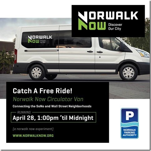 Those participating in the Citywide Scavenger Hunt on April 28th won’t have to get in their cars to search the city for clues. The Norwalk Parking Authority will be giving a trial run to a free shuttle from the Wall Street district to South Norwalk during the City Hunt.
The free shuttle will run from 1:00pm to 12 midnight on the day of the Scavenger Hunt, allowing people who are participating in the contest to get back and forth from SoNo to Wall Street. The vans are picking up and dropping off at several locations: in SoNo at the North Water Street Lot near the Maritime Aquarium’s IMAX entrance and the Maritime Garage, and in the Wall District in front of the Wall Street Theater and at the Yankee Doodle Garage. There will be parking attendants and signage.
The van service will also be available to people going out on the town that evening. The Parking Authority will monitor usage during this short period and evaluate to see if they will continue this service, perhaps on a limited basis.
“The idea of a shuttle circulating the two downtown areas of Norwalk has been discussed for a number of years. We thought that the Citywide Scavenger Hunt is a good opportunity to pilot the idea and gauge its popularity,” says Norwalk Mayor Harry Rilling. “I’ll be taking part in the hunt and riding the vans as well, and I look forward to talking to those who take advantage of this free service.”
The Citywide Scavenger Hunt will meet at O’Neill’s Pub & Restaurant at 10:30 a.m. on April 28. Participants will be “hunting” throughout the downtown districts for some several dozen clues, culminating in a party (to be disclosed during the hunt). There is a $40 entrance fee.
The Citywide Scavenger Hunt is being hosted by Norwalk Now, a part of MaxEx Public Relations, LLC, a marketing company that has entered a partnership with the Norwalk Parking Authority. The vans are provided and operated by LAZ Parking in collaboration with Norwalk Now and the Norwalk Parking Authority.
Norwalk Parking Authority works to develop programs that promote economic development and increase visitor activity in the downtown districts and the shuttle is part of that effort. “A circulator shuttle will help to make it easy for people to come downtown, enjoy a meal, go shopping, go to the movies, see a show and not have to worry about getting back in your car to go from one place to another,” says the Parking Authority’s director Kathryn Hebert.
Those participating in the Citywide Scavenger Hunt on April 28th won’t have to get in their cars to search the city for clues. The Norwalk Parking Authority will be giving a trial run to a free shuttle from the Wall Street district to South Norwalk during the City Hunt.
The free shuttle will run from 1:00pm to 12 midnight on the day of the Scavenger Hunt, allowing people who are participating in the contest to get back and forth from SoNo to Wall Street. The vans are picking up and dropping off at several locations: in SoNo at the North Water Street Lot near the Maritime Aquarium’s IMAX entrance and the Maritime Garage, and in the Wall District in front of the Wall Street Theater and at the Yankee Doodle Garage. There will be parking attendants and signage.
The van service will also be available to people going out on the town that evening. The Parking Authority will monitor usage during this short period and evaluate to see if they will continue this service, perhaps on a limited basis.
“The idea of a shuttle circulating the two downtown areas of Norwalk has been discussed for a number of years. We thought that the Citywide Scavenger Hunt is a good opportunity to pilot the idea and gauge its popularity,” says Norwalk Mayor Harry Rilling. “I’ll be taking part in the hunt and riding the vans as well, and I look forward to talking to those who take advantage of this free service.”
The Citywide Scavenger Hunt will meet at O’Neill’s Pub & Restaurant at 10:30 a.m. on April 28. Participants will be “hunting” throughout the downtown districts for some several dozen clues, culminating in a party (to be disclosed during the hunt). There is a $40 entrance fee.
The Citywide Scavenger Hunt is being hosted by Norwalk Now, a part of MaxEx Public Relations, LLC, a marketing company that has entered a partnership with the Norwalk Parking Authority. The vans are provided and operated by LAZ Parking in collaboration with Norwalk Now and the Norwalk Parking Authority.
Norwalk Parking Authority works to develop programs that promote economic development and increase visitor activity in the downtown districts and the shuttle is part of that effort. “A circulator shuttle will help to make it easy for people to come downtown, enjoy a meal, go shopping, go to the movies, see a show and not have to worry about getting back in your car to go from one place to another,” says the Parking Authority’s director Kathryn Hebert.Parking Minimums And How They Can Affect A City
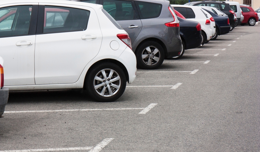 Hartford became the second major U.S. city to do away with mandatory parking minimums last year (Buffalo was the first). Parking minimums, which require builders to include a certain number of off-street parking spaces for buildings, have been popular the last 50+ years in many cities across the U.S. But what does this really mean for cities, and for its citizens?
Parking and City Revenues
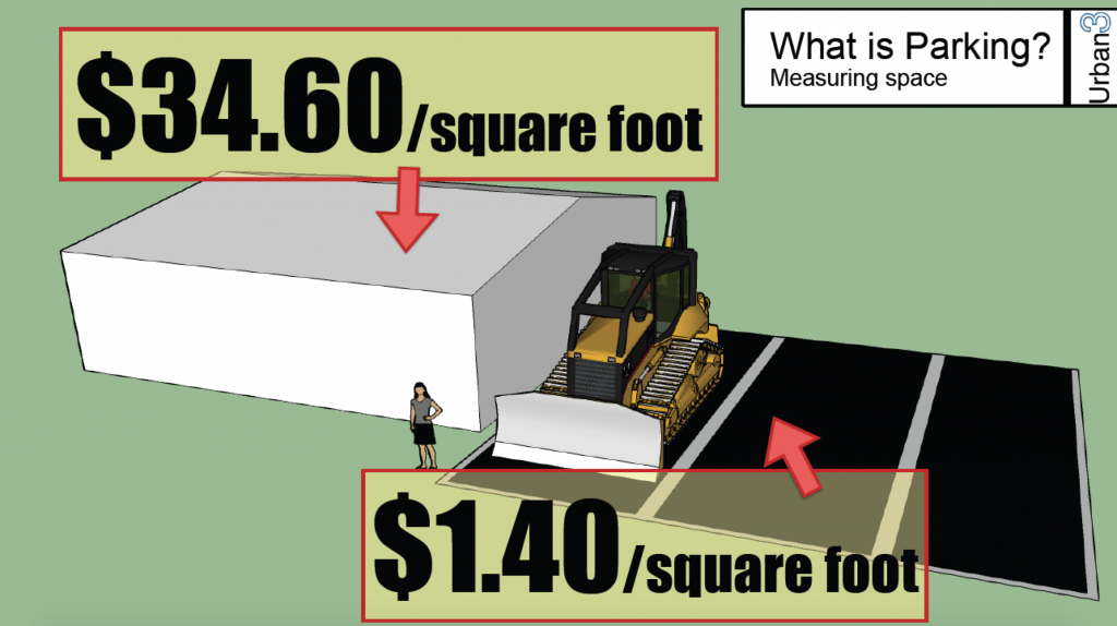
In cities, land is at a premium as they are constrained by the amount of land they can develop. It’s been argued that parking minimums fill cities with unproductive, parking spaces that don’t add value to the city and create barriers for new local businesses. With high minimum parking requirements for new buildings, there are more public and private garages, and parking gets favored versus buildings that can bring in higher tax revenues. Parking lots eat up a huge chunk of a city’s tax base. By enforcing parking minimums, the amount of productive land available for tax revenue is decreased. According to a 2014 study of several city downtowns, parking consumed so much land it amounted to $50 million a year in foregone tax revenue [1]. Another study also showed that parking minimums actually create a backwards tax incentive. Parking lots return 83 to 95 percent less property tax revenue to a city per acre than buildings do. This creates an incentive for landowners to tear down buildings and pave parking lots instead [2]. Two graphics from Urban3, an Asheville, NC based Urban Planning consulting firm, explain this well: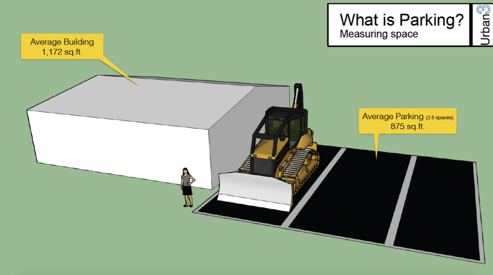 One parking space occupies 1.3 times the land that could have been used for a building - land that will frequently sit empty.
Parking Lots V.S. Building Stock
No minimums can help expand a downtown’s building stock. Without the burden of parking mandates, developers can more easily construct or renovate city buildings. Plus, the more parking spaces developers are required to create means less space for actual commercial space or residential units, which tends to raise rents. We can see an example of the effect of parking minimums on building stock by looking at some American small cities. Over the past 50 years, small cities such as Hartford or New Haven have devoted a large amount of space to parking. Other cities, such as Arlington, VA; Berkeley, CA; and Cambridge, MA; took a more restrictive approach to supplying ample parking. Over time in these latter three cities, off-street parking now takes up only five percent of land, while in other cities about 17% of land is devoted to parking.Parking and A Livable City
When a city mandates minimum parking, some important factors that make a modern “livable” city are ignored or removed. Many citizens express that they are looking for a city that is walkable, sprinkled with historic buildings and is as environmentally sustainable as possible. But, preservation gets short shrift from parking minimums as historic architecture is often replaced with parking. Parking minimums also encourage a “driving culture” for cities. With easy auto access, and easy parking, roads are more congested, hampering people’s ability to walk, bike, or take public transit. There are environmental implications to parking minimums as well. Convenient off-street parking promotes driving rather than encouraging the creation and use of efficient and expansive transit systems. With no parking minimums, traffic is reduced and there is less harmful runoff and greenhouse gas emissions. There is a big a tradeoff when considering the amount of parking in a city: either you have a dense, valuable urban area, or a location where it’s easy to drive. There are costs to parking minimums: inhibited development, loss of revenue for the city, higher cost of available space for consumers and businesses, and less reliance on and development of alternative means of transportation such as public transport or biking, to name a few. It may be time for more cities to consider doing a way with them.[1]. Dr. Norman Garrick, University of Connecticut's Center for Transportation and Livable Systems, 2014 [2] McCahill, Garrick, and co-authors Carol Atkinson-Palombo, Bryan Blanc, and Michael Gangi
Bikeable Neighborhoods
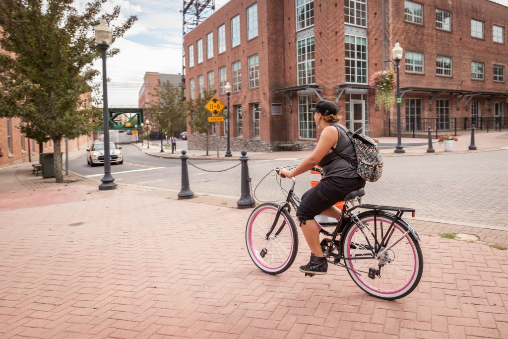
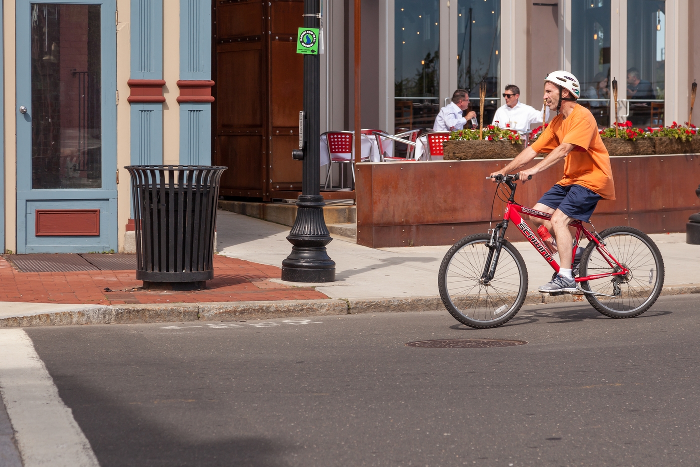 The bicycle as a mode of transportation, rather than simply for recreation, is getting more popular. With the increase in interest in reducing greenhouse gases and dependence on fossil fuels, cycling is returning to favor in many cities. One of the findings from the Norwalk Tomorrow Citywide Plan (POCD) Vision Forum in November was that many residents expressed a desire to have bikeable neighborhoods in Norwalk. Studies show more people are willing to ride bikes if cities provide infrastructure to support them. So what is a bikeable city, why is it desirable and how far is Norwalk on the path to being one?
Bike Friendly Cities
For urban planners, there has been a shift in recent years from trying to figure out how to move cars around a city, to how to incorporate public transportation, better sidewalks and other infrastructure for pedestrians and, of course, bicycling. While many European cities do this well, there are only a handful in the U.S. that can claim to be “bike friendly” such as Portland, Oregon, Chicago, Boulder, Co, New York City and San Francisco. Bike-friendly cities share several criteria:- Dedicated bike lanes or a network of bike paths
- Bicycle traffic signals
- Bike racks
- Cycling maps
- Bike sharing program
Bike Lanes and Paths
Bike paths are usually in parks or areas not designated for motor vehicles and are more oriented to the recreational biker. Bike lanes are lanes within city streets where bikes are protected. Bike lanes provide space and physical separation between the bicycle and the motor vehicle lane. For example, looking at the bikeable cities mentioned above, New York has built an average of 54 miles of bike lanes every year since 2007, while Chicago has added 27 miles per year since 2011. By providing dedicated bike lanes, cities attract more bikers. Portland State University found that when five major US cities added protected bike lanes, ridership rose 20 to 170 percent. It would stand to reason that more people would take to their bikes if they weren’t worried about collisions with cars.Bicycle Traffic Signals, Maps And Racks
Just as creating designated bike lanes in a city increases ridership, so does adding bicycle-friendly amenities that make it easier to get around a city on a bike or own a bike, easier. Traffic signals that give guidance at intersections for bicyclists only separates the movement of bikes, motor vehicles and pedestrians – keeping everyone safer. Maps help people get to where they’re going and racks provide a place to park your bike once you get there.Bicycle Traffic Signals, Maps And Racks
Just as creating designated bike lanes in a city increases ridership, so does adding bicycle-friendly amenities that make it easier to get around a city on a bike or own a bike, easier. Traffic signals that give guidance at intersections for bicyclists only separates the movement of bikes, motor vehicles and pedestrians – keeping everyone safer. Maps help people get to where they’re going and racks provide a place to park your bike once you get there.Bike Shares
For people who don’t want to invest in a bike, but like the idea of an alternative to public transportation or driving themselves, bike shares are an option that can increase the number of people on bikes in a city. If a city is considering a bike-sharing program, there are some important factors to ensure the program is successful. Bike-share programs get the highest ridership when they are in dense areas with protected bike lanes and connected to public transit. The overall sharing system should cover a sizeable area with equal access to bikes throughout the program area in order to provide meaningful coverage to entice people to ride. Data from Capital Bikeshare annual members in Washington, D.C., show that if stations are more than one-quarter mile (a 3- to 5-minute walk) from either their home or work, people don’t sign up. The program also notes that making sure that bike-share stations that are placed in close, visual proximity to transit stops can help people make first mile/last mile connections. Providing a single fare card that covers all modes of transportation also helps ridership.Benefits of A Bikeable City
Certainly there’s no argument that the health benefits of biking are a big draw for many people. Bikes are also much less expensive that owning a car. The savings are especially important for low-income residents who rely more on public transportation or walking. Biking reduces city traffic congestion and eases stress on parking availability. There’s also the perception that bike lanes improve a neighborhood's desirability. That same Portland State study showed that nearly three times as many residents felt that protected bike lanes had led to an increase in the desirability of living in their neighborhood, as opposed to a decrease in desirability (43% vs. 14%) In Norwalk in recent years has taken steps to encourage and increase biking in the city. A city Bike Walk Task Force was organized by the Mayor’s office in 2014. This task force, working with the city’s Department of Public Works, created a map outlining Norwalk’s existing bike routes, bike lanes and sharrows (shared-lane markings. They also put together a plan of bicycle lanes that could be created in the future that would be on approximately 5 % of city streets. Those bike lanes were planned and designed in accordance with AASHTO (American Association of State Highway and Transportation Officials) standards and Connecticut Department of Transportation (ConnDOT) requirements. As of late 2017, this taskforce became a permanent BikeWalk Advisory Commission with seven members nominated by the mayor and appointed by the council. Bikes are quiet, clean, small, sustainable, and make riders fitter. If a city makes adjustments to promote biking such as bike lanes, maps, designated lights and bike shares, accidents with motorists will be reduced and more people will be encouraged to bike. With more bikers on the roads, this strength in numbers can influence the political will to build even more bike infrastructure.Parking Capacity Study & Strategic Parking Plan Update
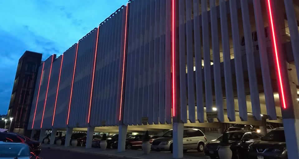
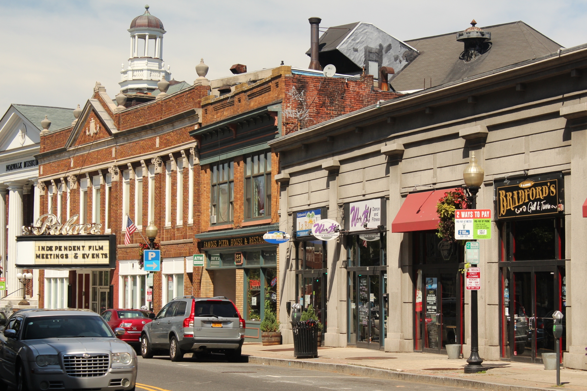 The Norwalk Parking Authority (NPA) oversees and manages more than 4,000 on and off-street parking spaces. The off-street parking spots are in nine facilities including two railroad stations, three garages and six open lots. The Authority started a yearlong planning study late in 2017, the first part of which is to assess the current parking situation in Norwalk.
During the latter half of 2017, the Parking Authority, working with Walker Parking Consultants, conducted research both on the current usage of parking facilities and also gathered stakeholder input to understand the community’s goals and needs. The NPA, through Walker Consultants, held individual face-to-face and telephone interviews and collected data from the downtown districts and the railroad stations through on-the-spot street interviews with commuters and the public. In addition, an online survey was made available for members of the public to provide feedback. Below is some of what was discovered during this phase.
The Norwalk Parking Authority (NPA) oversees and manages more than 4,000 on and off-street parking spaces. The off-street parking spots are in nine facilities including two railroad stations, three garages and six open lots. The Authority started a yearlong planning study late in 2017, the first part of which is to assess the current parking situation in Norwalk.
During the latter half of 2017, the Parking Authority, working with Walker Parking Consultants, conducted research both on the current usage of parking facilities and also gathered stakeholder input to understand the community’s goals and needs. The NPA, through Walker Consultants, held individual face-to-face and telephone interviews and collected data from the downtown districts and the railroad stations through on-the-spot street interviews with commuters and the public. In addition, an online survey was made available for members of the public to provide feedback. Below is some of what was discovered during this phase.
Current Parking Use
In the Wall Street area, occupancy during the week is largest in the Wall Street lot at 73% full. In contrast, the Main Street lot and Yankee Doodle Garage are not as busy with only 47% and 54% occupancy rates, respectively. During the weekend, at midday on Saturday for example, all of these parking areas are equally busy, with an average occupancy rate of 68%. In South Norwalk, the SoNo train station garage and lot are nearly full on weekdays, an average of 98% occupied. Similarly, the Webster lot also sees high occupancies during the week, about 91% full. The Haviland Garage and Water Street lot are fairly busy with 74% and 78% occupancy rates. The least busy is the Maritime Garage that is only about half full at 52%. In contrast, on the weekend, it is the Water Street lot and Haviland Garages that see more cars, being about 89% and 78% occupied.Public Surveys
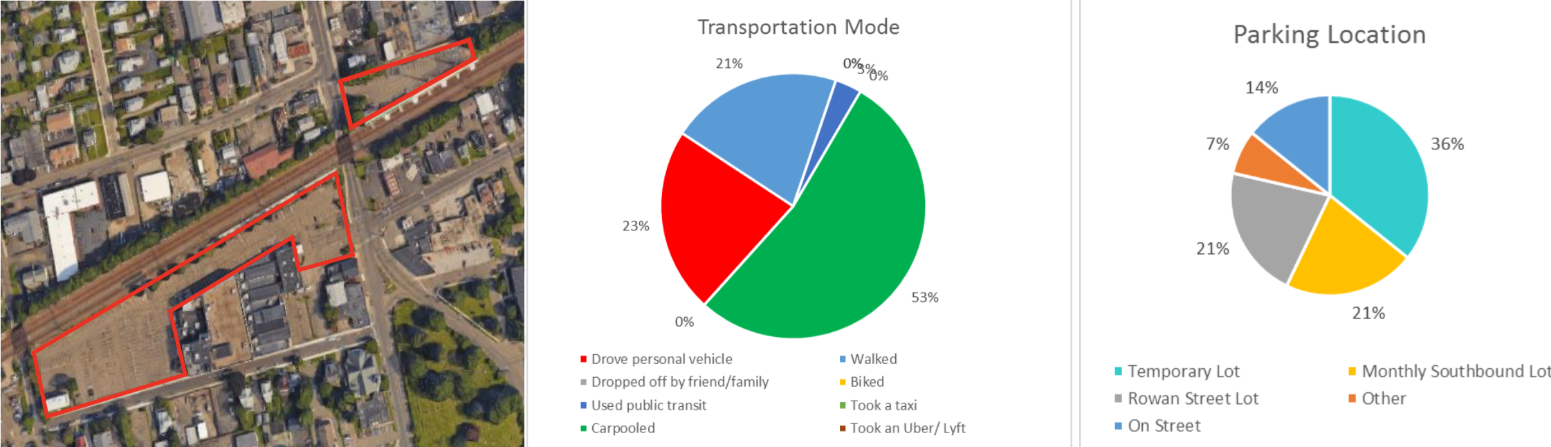
The NPA surveyed commuters in both the South Norwalk and East Norwalk train stations to get an idea of their parking profiles and concerns. In East Norwalk, the majority of commuters surveyed carpooled or took a taxi (53%). For the 23% who drove their own car, most (36%) parked in the temporary lot, followed by the train station southbound lot and the northbound lot.East Norwalk Station Survey Results
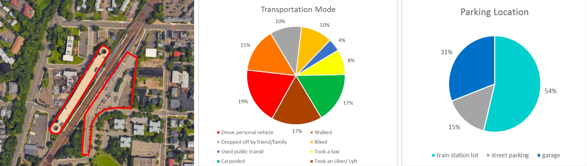
 At the South Norwalk railroad station, the majority of commuters (19%) drove their own vehicle to the train station, followed by either carpooling or taking an Uber or Lyft (both 17%). Of those driving, the majority (85%) parked in the train station garage or lot, only 15% parked on the street.
South Norwalk Station Survey Results
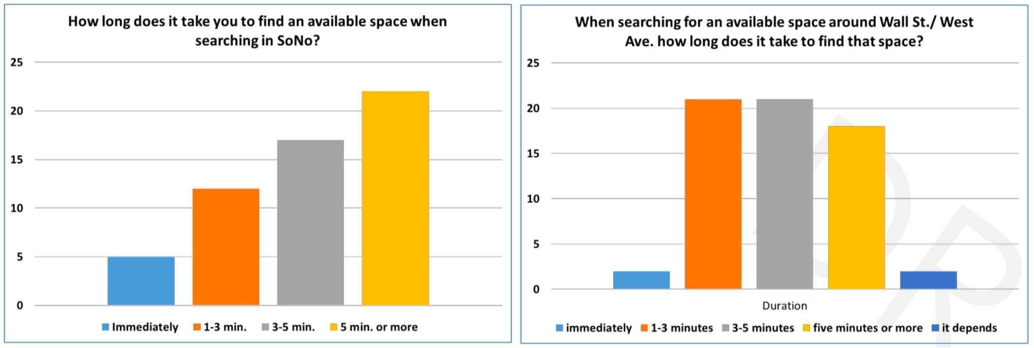
 The NPA conducted a public survey at a Norwalk Open House late in 2017 that revealed some parking perceptions. For many who answered the survey, the most important parking issue in both the Wall Street/West Avenue area and in South Norwalk was finding an available space. Interesting to note, however, that respondents said that it takes only 1-5 minutes to find a parking spot in the Wall Street/West Avenue area. For SoNo, it took them 5 minutes or more.
 The next steps before drafting the parking plan will be to review parking management and operational policies and governance and how they compare to industry best practices. The NPA will also take consider parking capacity solutions, including alternative mobility options and opportunities, such as a shuttle that circulates around town or bike sharing, and parking zoning changes looking at all of the planned citywide development buildout. In addition, a review and recommendation of technology is also in the works. The final goal is to have a plan that achieves consensus and provides a forward-looking blueprint for the future that is responsive to the unique needs of Norwalk. A draft plan for public review is expected later in 2018.
To review a presentation on the status of the Parking Plan, Click Here.
The next steps before drafting the parking plan will be to review parking management and operational policies and governance and how they compare to industry best practices. The NPA will also take consider parking capacity solutions, including alternative mobility options and opportunities, such as a shuttle that circulates around town or bike sharing, and parking zoning changes looking at all of the planned citywide development buildout. In addition, a review and recommendation of technology is also in the works. The final goal is to have a plan that achieves consensus and provides a forward-looking blueprint for the future that is responsive to the unique needs of Norwalk. A draft plan for public review is expected later in 2018.
To review a presentation on the status of the Parking Plan, Click Here.The Challenges of Ride Hailing Services For A City
 The takeoff of ride-hailing services such as Uber and Lyft has created challenges for cities. While consumers generally find them convenient and easy to use, they can take people away from using public transportation, add more congestion to city streets and generally cost more to residents.
Ride services may seem like a good alternative to using your own car, but they tend to compete more with public transportation. According to a recent study out of UC Davis Institute of Transportation Studies, public transportation is used less in major cities when their residents adopt ride-hailing services such as Uber and Lyft. Rather than walking, bicycling or taking public transportation, they’re catching a ride on one of these services. How will cities respond to fewer riders on public transportation? Will fares increase? Will they reduce number of routes and/or frequency?
With fewer people walking or biking and taking car services, this leads to more cars on city streets. New York City has definitely felt this increased congestion with the explosion of ride-hailing services. According to the Taxi and Limousine Commission, currently there are 68,000 vehicles affiliated with ride-hailing app companies, 65,000 with Uber alone. City law caps the number of yellow taxis at a little below 13,600. In 2013, there were 47,000 vehicles for hire in total on the roads. All this car traffic has slowed the roads down to an average of 4.7 miles per hour – a drop from 6.5 miles per hour five years ago, according to the New York Times. Not only does this cause frustration for city dwellers, with more cars on city streets, the risk of accidents increases and air pollution get worse.
Cities and states have begun to take action to regulate ride-hailing services. New York State is working on a congestion-pricing plan to reduce traffic in Manhattan that might include a new per-ride fee passengers of for-hire vehicles will have to pay. The hope would be to reduce the number of vehicles on city streets, and as a benefit, the funds would raise money to modernize the New York City subway system.
For Norwalk and Connecticut residents, new rules for ride-hailing services have taken effect in Connecticut this year. For example, these services now have to register with the Department of Transportation (DOT) and pay state fees each year. Drivers must be given background checks have $1 million in liability insurance coverage once a passenger gets in the vehicle. This makes Connecticut the 43rd state with a law that regulates ride-sharing companies. While certainly this law will make ride-sharing services safer for riders, it doesn’t tackle the issues of congestion and public transportation – issues that may become more of a problem as these vehicle-for-hire services get more popular.
1 The New York Times,: https://www.nytimes.com/2017/12/26/nyregion/uber-car-congestion-pricing-nyc.html?smprod=nytcore-ipad&smid=nytcore-ipad-share
http://money.cnn.com/2017/10/11/technology/future/ride-hailing-cities-public-transit/index.html
http://schallerconsult.com/rideservices/unsustainable.htm
https://steps.ucdavis.edu/new-research-ride-hailing-impacts-travel-behavior/
The takeoff of ride-hailing services such as Uber and Lyft has created challenges for cities. While consumers generally find them convenient and easy to use, they can take people away from using public transportation, add more congestion to city streets and generally cost more to residents.
Ride services may seem like a good alternative to using your own car, but they tend to compete more with public transportation. According to a recent study out of UC Davis Institute of Transportation Studies, public transportation is used less in major cities when their residents adopt ride-hailing services such as Uber and Lyft. Rather than walking, bicycling or taking public transportation, they’re catching a ride on one of these services. How will cities respond to fewer riders on public transportation? Will fares increase? Will they reduce number of routes and/or frequency?
With fewer people walking or biking and taking car services, this leads to more cars on city streets. New York City has definitely felt this increased congestion with the explosion of ride-hailing services. According to the Taxi and Limousine Commission, currently there are 68,000 vehicles affiliated with ride-hailing app companies, 65,000 with Uber alone. City law caps the number of yellow taxis at a little below 13,600. In 2013, there were 47,000 vehicles for hire in total on the roads. All this car traffic has slowed the roads down to an average of 4.7 miles per hour – a drop from 6.5 miles per hour five years ago, according to the New York Times. Not only does this cause frustration for city dwellers, with more cars on city streets, the risk of accidents increases and air pollution get worse.
Cities and states have begun to take action to regulate ride-hailing services. New York State is working on a congestion-pricing plan to reduce traffic in Manhattan that might include a new per-ride fee passengers of for-hire vehicles will have to pay. The hope would be to reduce the number of vehicles on city streets, and as a benefit, the funds would raise money to modernize the New York City subway system.
For Norwalk and Connecticut residents, new rules for ride-hailing services have taken effect in Connecticut this year. For example, these services now have to register with the Department of Transportation (DOT) and pay state fees each year. Drivers must be given background checks have $1 million in liability insurance coverage once a passenger gets in the vehicle. This makes Connecticut the 43rd state with a law that regulates ride-sharing companies. While certainly this law will make ride-sharing services safer for riders, it doesn’t tackle the issues of congestion and public transportation – issues that may become more of a problem as these vehicle-for-hire services get more popular.
1 The New York Times,: https://www.nytimes.com/2017/12/26/nyregion/uber-car-congestion-pricing-nyc.html?smprod=nytcore-ipad&smid=nytcore-ipad-share
http://money.cnn.com/2017/10/11/technology/future/ride-hailing-cities-public-transit/index.html
http://schallerconsult.com/rideservices/unsustainable.htm
https://steps.ucdavis.edu/new-research-ride-hailing-impacts-travel-behavior/