Resilient South Norwalk Final Report – November 2023
June 29th, 2023 Public Workshop
January 12, 2023 Public Workshop
Climate change has made areas that are prone to flooding or extreme heat more vulnerable. The Connecticut Institute for Resilience and Climate Adaptation (CIRCA) initiated Resilient Connecticut in 2018 to plan for these weather-related challenges. CIRCA has identified Norwalk as a community that is not only subject to impacts from our changing climate but also has vulnerable populations and critical infrastructure that could be affected. Circa, in partnership with the Norwalk Planning & Zoning Department, will conduct an initial look at potential flooding resilience efforts and impact in South Norwalk. To lead this effort, CIRCA has brought on the consulting firm AECOM to help address these issues related to climate change and resilience.
In South Norwalk, CIRCA research has shown that flood risks from storm surges, tidal flooding, heavy rain, and stormwater pose public safety issues for residents such as storm damage to buildings and infrastructure and access to lifelines, and evacuation routes during storms.
In addition, much of the South Norwalk area is vulnerable to extreme heat because of the limited tree canopy, which the City is addressing, while also reducing the high amount of impervious surface.
South Norwalk is home to a diverse population of residents with varying access to resources. Residents with fewer available resources – whether due to income, housing, age, transportation, or language access – are less able to adapt, and are therefore, more vulnerable to climate change.
Goal of Resilient South Norwalk
The Resilient South Norwalk Project’s goal is to develop strategies and adaptations that will help reduce the impact of climate-induced flooding and of extreme heat on the community’s residents, City infrastructure, and transportation, as well as improve the adjacent, valuable ecological systems. The kinds of solutions that may be considered are road elevations or relocations, flood protection systems, green infrastructure for stormwater management, increasing the tree canopy, and building retrofits for heat mitigation.
As part of the project, Norwalk will review existing conditions and analysis by CIRCA on flooding and areas with extreme heat, as well as any current plans.
Planning Areas and Activities

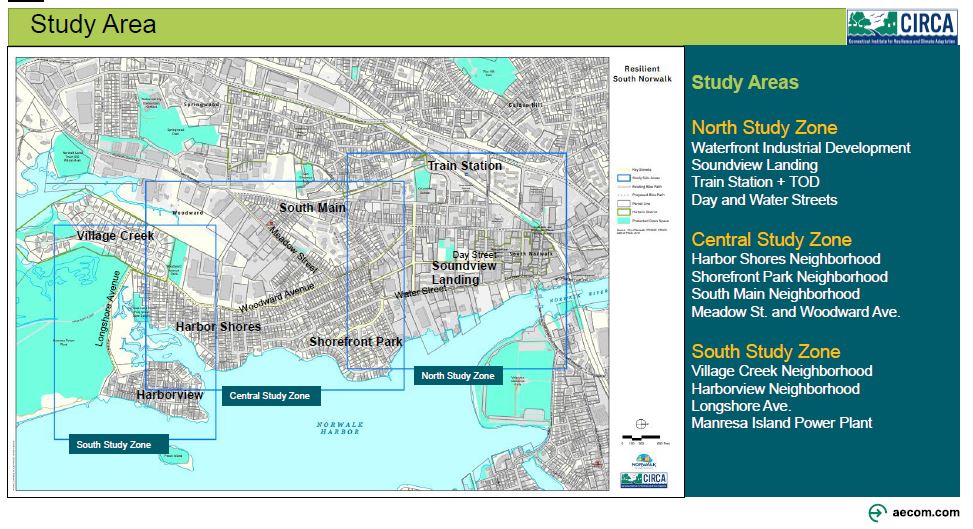
The plan will focus on three zones in South Norwalk, identified on the map above as North, Central, and South. Within those zones the study will look at the following:
- Creating flood mitigation options and needed adjustments to critical transportation corridors
- Maintaining dry emergency evacuation corridors when it floods, as well as reducing flooding of critical community assets
- Establishing “resilient corridors” to maintain access for residents, emergency vehicles, and critical services during storm events and flooding
- Assessing how land is used, the density of buildings, particularly in areas with vulnerable populations
- Reducing the impact of extreme temperatures and “heat islands” or pockets of the area that are significantly warmer than surrounding areas, including nature-based ways
Input and Participation
The planning team will work with the steering committee, and community stakeholders, such as neighborhood residents and businesses, to learn their priorities and then take them into consideration as they make plans. This will be done through four steering committee meetings, three public workshops, outreach materials, and updates via a website and social media. The goal is to wrap up the project in May of 2023.
This CIRCA-funded project is a component of the U.S. Department of Housing and Urban Development (HUD) National Disaster Resilience Competition award to the State of Connecticut, administered by the Connecticut Department of Housing. Resilient Connecticut provides the state with funds for the design and engagement process.


